IMAGES TAKEN NEAR TO
Altus Street, BICESTER, OX25 5DB
Introduction
This page details the photographs taken nearby to Altus Street, OX25 5DB by members of the Geograph project.
The Geograph project started in 2005 with the aim of publishing, organising and preserving representative images for every square kilometre of Great Britain, Ireland and the Isle of Man.

There are currently over 7.5m images from over14,400 individuals and you can help contribute to the project by visiting https://www.geograph.org.uk
Image Map
Images are licensed for reuse under creativecommons.org/licenses/by-sa/2.0
Notes
- Clicking on the map will re-center to the selected point.
- The higher the marker number, the further away the image location is from the centre of the postcode.
Image Listing (8 Images Found)
Images are licensed for reuse under creativecommons.org/licenses/by-sa/2.0
Image
Details
Distance
1
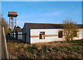
Old Huts, Upper Heyford Airfield
A few of many such buildings in this derelict part of the site.
Image: © Des Blenkinsopp
Taken: 12 Mar 2012
0.04 miles
3
Ex-USAF base To Let
Upper Heyford was formally handed over to the USAF 3rd Air Force on 15 May 1951 and on 30 September 1994 the base was returned to the Ministry of Defence. More details of what happened between these dates: http://en.wikipedia.org/wiki/RAF_Upper_Heyford
Image: © Stuart Logan
Taken: 31 Mar 2013
0.08 miles
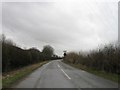
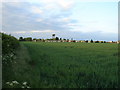
4
Footpath to Upper Heyford
Somebody has been busy with a knapsack sprayer and some "Roundup"
Image: © Michael Trolove
Taken: 22 May 2010
0.13 miles
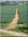
5
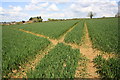
Tractor tracks crossing footpath leading to Camp Road
Image: © Roger Templeman
Taken: 27 Apr 2016
0.16 miles
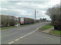
6
Old MOD Buildings at Upper Heyford
Old, but still in use it would seem.
Image: © Ian Paterson
Taken: 23 May 2007
0.18 miles
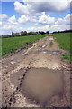
8

Bridleway nears wire fence
Bridleway nears wire fence of old USAF Upper Heyford with an impassable overgrown turn to the left
Image: © Shaun Ferguson
Taken: 11 Aug 2020
0.24 miles