IMAGES TAKEN NEAR TO
Wilson Close, BICESTER, OX25 5BE
Introduction
This page details the photographs taken nearby to Wilson Close, OX25 5BE by members of the Geograph project.
The Geograph project started in 2005 with the aim of publishing, organising and preserving representative images for every square kilometre of Great Britain, Ireland and the Isle of Man.

There are currently over 7.5m images from over14,400 individuals and you can help contribute to the project by visiting https://www.geograph.org.uk
Image Map
Images are licensed for reuse under creativecommons.org/licenses/by-sa/2.0
Notes
- Clicking on the map will re-center to the selected point.
- The higher the marker number, the further away the image location is from the centre of the postcode.
Image Listing (18 Images Found)
Images are licensed for reuse under creativecommons.org/licenses/by-sa/2.0
Image
Details
Distance
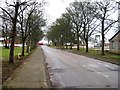
2
Carswell Circle
Ex military housing attached to Upper Heyford airfield. Now civilian tenancies.
Image: © Des Blenkinsopp
Taken: 12 Mar 2012
0.08 miles
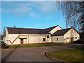
3
Now a Museum
The former base commander's building by the main gate to Upper Heyford airfield.
There is still a checkpoint outside, controlling access to what is now Upper Heyford Business Park.
The first floor houses a museum of the airfield's service days. http://www.raf-upper-heyford.org/Museum.html
The following wonderful bit of aviation trivia is a snippet from that site.
"RAF Upper Heyford is the only base in the world that had an aircraft named after it. The Heyford was a twin engine, bi-plane bomber that saw service between the wars, and to my knowledge never fired a shot, or dropped a bomb in anger."
Image: © Des Blenkinsopp
Taken: 12 Mar 2012
0.16 miles
6
Communications Building
The sign reads 620th Communications Squadron. This was a working military airfield until 1993 but a lot of the buildings look distinctly World War 2.
Nice to know our taxes aren't being frittered on fancy huts.
Image: © Des Blenkinsopp
Taken: 12 Mar 2012
0.19 miles
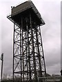
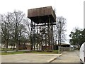
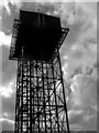
8
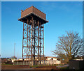
Water Tower, Upper Heyford Airfield
This may well still be in service as many of the former military buildings and houses on the airfield site are now in civilian use.
Image: © Des Blenkinsopp
Taken: 12 Mar 2012
0.20 miles
9
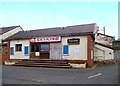
Skyking Theater
Another boarded up and disused facility on the Upper Heyford site.
Image: © Des Blenkinsopp
Taken: 12 Mar 2012
0.20 miles