IMAGES TAKEN NEAR TO
Shepherds Hill, BICESTER, OX25 4TH
Introduction
This page details the photographs taken nearby to Shepherds Hill, OX25 4TH by members of the Geograph project.
The Geograph project started in 2005 with the aim of publishing, organising and preserving representative images for every square kilometre of Great Britain, Ireland and the Isle of Man.

There are currently over 7.5m images from over14,400 individuals and you can help contribute to the project by visiting https://www.geograph.org.uk
Image Map
Images are licensed for reuse under creativecommons.org/licenses/by-sa/2.0
Notes
- Clicking on the map will re-center to the selected point.
- The higher the marker number, the further away the image location is from the centre of the postcode.
Image Listing (11 Images Found)
Images are licensed for reuse under creativecommons.org/licenses/by-sa/2.0
Image
Details
Distance
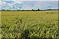
1
Westfield Farm and new housing in Coneygar Fields
Image: © Roger Templeman
Taken: 22 Apr 2016
0.06 miles
2
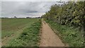
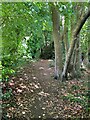
Fenway heading past Shepherds Hill
Fenway heading past Shepherds Hill heading down into Steeple Aston
Image: © Shaun Ferguson
Taken: 30 Apr 2021
0.08 miles
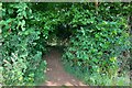
3
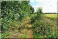
Restricted Byway heading to Three Corner Clump
From Fenway the Restricted Byway heading to Three Corner Clump
Image: © Shaun Ferguson
Taken: 30 Apr 2021
0.11 miles
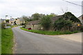
4
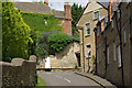
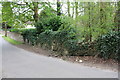
Steeple Aston
The top of Water Lane and its junction with North Side.
Image: © Stephen McKay
Taken: 20 May 2007
0.18 miles
6
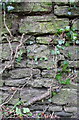
Benchmark on Water Lane wall
Ordnance Survey cut mark benchmark described on the Bench Mark Database at http://www.bench-marks.org.uk/bm75073
Image: © Roger Templeman
Taken: 22 Apr 2016
0.20 miles
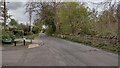
8
Stone wall beside Water Lane
There is an OS benchmark Image on the wall right of the water main marker post
Image: © Roger Templeman
Taken: 22 Apr 2016
0.21 miles