IMAGES TAKEN NEAR TO
Heyford Road, BICESTER, OX25 4SU
Introduction
This page details the photographs taken nearby to Heyford Road, OX25 4SU by members of the Geograph project.
The Geograph project started in 2005 with the aim of publishing, organising and preserving representative images for every square kilometre of Great Britain, Ireland and the Isle of Man.

There are currently over 7.5m images from over14,400 individuals and you can help contribute to the project by visiting https://www.geograph.org.uk
Image Map
Images are licensed for reuse under creativecommons.org/licenses/by-sa/2.0
Notes
- Clicking on the map will re-center to the selected point.
- The higher the marker number, the further away the image location is from the centre of the postcode.
Image Listing (42 Images Found)
Images are licensed for reuse under creativecommons.org/licenses/by-sa/2.0
Image
Details
Distance
1
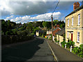
Steeple Aston
Original home of the "Steeple Aston Cope". The medieval cope or cloak, embroidered with gold and silver thread on silk twill, is now in the V & A Museum. It had been in the village for centuries until discovered hidden away in a chest in the 19th. century. It is considered one of the finest examples of its period in Europe.
Image: © Jurek and Trish Sienkiewicz
Taken: 9 May 2005
0.02 miles
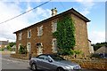
3
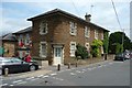
Manor House and post office, Steeple Aston
Manor House is the name I remembered, but evidently not the 17C Manor House Farm mentioned by Nikolaus Pevsner in The Buildings of England - Oxfordshire.
Image: © Humphrey Bolton
Taken: 25 Jun 2011
0.05 miles
5
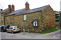
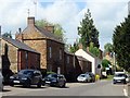
Outbuilding attached to 'Holly Tree' at Harrisville/South Side junction
There is an OS benchmark Image on the near corner, left hand face, of the building
Image: © Roger Templeman
Taken: 22 Apr 2016
0.06 miles
6
Steeple Aston Manor House
On the corner of Southside and Paines Hill.
Image: © Ian Rob
Taken: 15 Aug 2019
0.06 miles
7
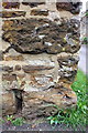
Benchmark on building next to 'Holly Tree'
Ordnance Survey cut mark benchmark described on the Bench Mark Database at http://www.bench-marks.org.uk/bm75074
Image: © Roger Templeman
Taken: 22 Apr 2016
0.06 miles
9
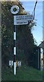
Old Direction Sign - Signpost by South Side, Steeple Aston
Annulus finial - 2 arms; Oxford CC halo by the UC road, in parish of Steeple Aston (Cherwell District), South Side, opposite Paines Hill, on verge.
To be surveyed
Milestone Society National ID: OX_SP4725.
Image: © Milestone Society
Taken: Unknown
0.07 miles
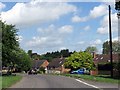
10
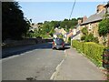
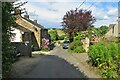
Paines Hill
Paines Hill in the village of Steeple Aston.
Image: © Philip Halling
Taken: 6 Sep 2021
0.08 miles