IMAGES TAKEN NEAR TO
Kirtlington Road, BICESTER, OX25 4NB
Introduction
This page details the photographs taken nearby to Kirtlington Road, OX25 4NB by members of the Geograph project.
The Geograph project started in 2005 with the aim of publishing, organising and preserving representative images for every square kilometre of Great Britain, Ireland and the Isle of Man.

There are currently over 7.5m images from over14,400 individuals and you can help contribute to the project by visiting https://www.geograph.org.uk
Image Map
Images are licensed for reuse under creativecommons.org/licenses/by-sa/2.0
Notes
- Clicking on the map will re-center to the selected point.
- The higher the marker number, the further away the image location is from the centre of the postcode.
Image Listing (10 Images Found)
Images are licensed for reuse under creativecommons.org/licenses/by-sa/2.0
Image
Details
Distance
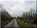
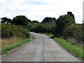
3
Port Way heading north
Port Way is a pre-Roman road running from Kirtlington.
Image: © Steve Daniels
Taken: 7 Sep 2015
0.10 miles
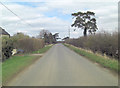
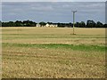
4
Port Way heading south
Port Way is a pre-Roman road leading to Kirtlington.
Image: © Steve Daniels
Taken: 7 Sep 2015
0.14 miles
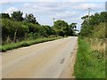
6
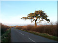
Tree and Empty Road
A Lonesome Pine beside the Port Way.
Image: © Des Blenkinsopp
Taken: 12 Mar 2012
0.16 miles
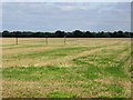
8
Path heading to Port Way
Path heading across the field to Port Way
Image: © Shaun Ferguson
Taken: 11 Aug 2020
0.20 miles
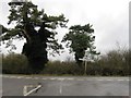
9
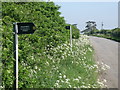
This way, that way
Footpath signs to Goldwell Spinney and Lower Heyford.
Image: © Michael Trolove
Taken: 22 May 2010
0.21 miles