IMAGES TAKEN NEAR TO
Weston-on-the-Green, BICESTER, OX25 3WQ
Introduction
This page details the photographs taken nearby to OX25 3WQ by members of the Geograph project.
The Geograph project started in 2005 with the aim of publishing, organising and preserving representative images for every square kilometre of Great Britain, Ireland and the Isle of Man.

There are currently over 7.5m images from over14,400 individuals and you can help contribute to the project by visiting https://www.geograph.org.uk
Image Map
Images are licensed for reuse under creativecommons.org/licenses/by-sa/2.0
Notes
- Clicking on the map will re-center to the selected point.
- The higher the marker number, the further away the image location is from the centre of the postcode.
Image Listing (2 Images Found)
Images are licensed for reuse under creativecommons.org/licenses/by-sa/2.0
Image
Details
Distance
1
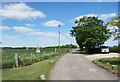
Driveway to Oddington Grange
The public road which has just crossed the railway on a brand new bridge ends here at Oddington Cottage and continues to the Grange as a private drive.
Image: © Des Blenkinsopp
Taken: 14 May 2020
0.25 miles
2
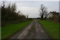
End of the public highway, near Oddington Grange
A tangle of public rights of way and some earthworks suggest that there was once a larger settlement around here, but now only a few cottages and Oddington Grange lie along this dead-end lane.
Image: © Christopher Hilton
Taken: 2 Dec 2014
0.25 miles