IMAGES TAKEN NEAR TO
Northampton Road, BICESTER, OX25 3TL
Introduction
This page details the photographs taken nearby to Northampton Road, OX25 3TL by members of the Geograph project.
The Geograph project started in 2005 with the aim of publishing, organising and preserving representative images for every square kilometre of Great Britain, Ireland and the Isle of Man.

There are currently over 7.5m images from over14,400 individuals and you can help contribute to the project by visiting https://www.geograph.org.uk
Image Map
Images are licensed for reuse under creativecommons.org/licenses/by-sa/2.0
Notes
- Clicking on the map will re-center to the selected point.
- The higher the marker number, the further away the image location is from the centre of the postcode.
Image Listing (5 Images Found)
Images are licensed for reuse under creativecommons.org/licenses/by-sa/2.0
Image
Details
Distance
1
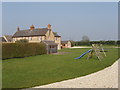
New Barn Farm, Weston on the Green
The line of the public footpath is across the grass between the play equipment and the house - I walked discreetly round the drive.
Image: © David Hawgood
Taken: 27 Mar 2007
0.02 miles
2
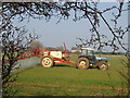
Spraying wheat at New Barn farm
I had just walked on the public footpath across the wheat from the farmhouse and was on the stile when the sprayer came by.
Image: © David Hawgood
Taken: 27 Mar 2007
0.12 miles
3
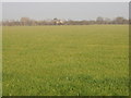
Footpath not apparent through wheat field
The footpath runs across to New Barn Farm, visible beyond the hedge.
Image: © David Hawgood
Taken: 27 Mar 2007
0.19 miles
4
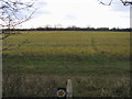
Footpath to Gaerleon
From New Barn Farm the footpath to Gaerleon
Image: © Shaun Ferguson
Taken: 29 Dec 2011
0.21 miles
5
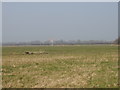
Weston-on-the-Green grass airfield for parachuting and gliding
The airfield is used for military parachuting, also by Oxford Gliding Club who warn "With the level of parachute activity described, it would be foolhardy to blunder into the airspace above the airfield without knowing what is going on."
Image: © David Hawgood
Taken: 27 Mar 2007
0.23 miles