IMAGES TAKEN NEAR TO
Ambrosden, BICESTER, OX25 2SP
Introduction
This page details the photographs taken nearby to OX25 2SP by members of the Geograph project.
The Geograph project started in 2005 with the aim of publishing, organising and preserving representative images for every square kilometre of Great Britain, Ireland and the Isle of Man.

There are currently over 7.5m images from over14,400 individuals and you can help contribute to the project by visiting https://www.geograph.org.uk
Image Map
Images are licensed for reuse under creativecommons.org/licenses/by-sa/2.0
Notes
- Clicking on the map will re-center to the selected point.
- The higher the marker number, the further away the image location is from the centre of the postcode.
Image Listing (7 Images Found)
Images are licensed for reuse under creativecommons.org/licenses/by-sa/2.0
Image
Details
Distance
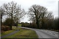
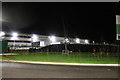
2

The road from Ambrosden meets the A41
Image: © Sarah Charlesworth
Taken: 22 Mar 2010
0.23 miles
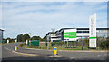
3
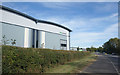
Units at Symmetry Park
A new business park beside the A41 on the edge of Bicester.
Image: © Des Blenkinsopp
Taken: 14 Sep 2019
0.23 miles
4
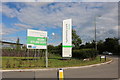
The entrance to Symmetry Park Bicester
It's nearer to Ambrosden but most people wouldn't be able to find it if they used that.
Image: © David Howard
Taken: 8 Jun 2019
0.23 miles
6
Bentley Design at Symmetry Park, Bicester
Nothing to do with cars, it's a furniture factory and recently built on a greenfield site. https://www.bentleydesigns.com/
Image: © David Howard
Taken: 9 Feb 2019
0.24 miles
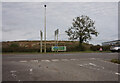
7
Morrell Way, Symmetry Park
A short service road leading into a business park.
Image: © Des Blenkinsopp
Taken: 14 Sep 2019
0.25 miles