IMAGES TAKEN NEAR TO
Ploughley Road, BICESTER, OX25 2RB
Introduction
This page details the photographs taken nearby to Ploughley Road, OX25 2RB by members of the Geograph project.
The Geograph project started in 2005 with the aim of publishing, organising and preserving representative images for every square kilometre of Great Britain, Ireland and the Isle of Man.

There are currently over 7.5m images from over14,400 individuals and you can help contribute to the project by visiting https://www.geograph.org.uk
Image Map
Images are licensed for reuse under creativecommons.org/licenses/by-sa/2.0
Notes
- Clicking on the map will re-center to the selected point.
- The higher the marker number, the further away the image location is from the centre of the postcode.
Image Listing (10 Images Found)
Images are licensed for reuse under creativecommons.org/licenses/by-sa/2.0
Image
Details
Distance
3
Birch Road, Ambrosden
The old car is shown in more detail in Image
Image: © Des Blenkinsopp
Taken: 14 Sep 2019
0.20 miles
4
Ploughley Road from Blackthorn Lane, Ambrosden
Image: © Ian S
Taken: 9 Oct 2020
0.22 miles
5
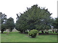
Cherwell Churches Christmas chug through (55)
Trees in Ambrosden Churchyard
Image: © Basher Eyre
Taken: 28 Dec 2019
0.22 miles
6
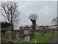
Cherwell Churches Christmas chug through (53)
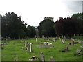
St Mary, Ambrosden: churchyard
Image: © Basher Eyre
Taken: 28 Dec 2019
0.23 miles
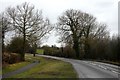
7
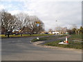
Ploughley Road, Ambrosden
I can't find the name of the adjoining road so far
Image: © David Howard
Taken: 20 Mar 2016
0.24 miles
8
Cherwell Churches Christmas chug through (57)
Ambrosden Churchyard
Image: © Basher Eyre
Taken: 28 Dec 2019
0.24 miles
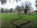
9
Churchyard of St Mary the Virgin church, Ambrosden
Image: © David Purchase
Taken: 6 Aug 2017
0.25 miles
10
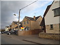
New houses on Merton Road
The design is anything but new but the construction is
Image: © David Howard
Taken: 20 Mar 2016
0.25 miles