IMAGES TAKEN NEAR TO
Wendlebury, BICESTER, OX25 2PW
Introduction
This page details the photographs taken nearby to OX25 2PW by members of the Geograph project.
The Geograph project started in 2005 with the aim of publishing, organising and preserving representative images for every square kilometre of Great Britain, Ireland and the Isle of Man.

There are currently over 7.5m images from over14,400 individuals and you can help contribute to the project by visiting https://www.geograph.org.uk
Image Map
Images are licensed for reuse under creativecommons.org/licenses/by-sa/2.0
Notes
- Clicking on the map will re-center to the selected point.
- The higher the marker number, the further away the image location is from the centre of the postcode.
Image Listing (30 Images Found)
Images are licensed for reuse under creativecommons.org/licenses/by-sa/2.0
Image
Details
Distance
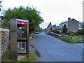
1
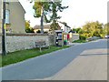
Wendlebury, street furniture
Seat, phone box, litter bin, notice board and postbox, on Main Street.
Image: © Mike Faherty
Taken: 1 Oct 2011
0.01 miles
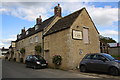
2
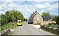
The Lion at Wendlebury
The Red Lion in earlier pictures, but now just The Lion.
Image: © Des Blenkinsopp
Taken: 15 Jun 2020
0.03 miles
3
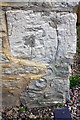
Benchmark on The Lion of Wendlebury
Ordnance Survey cut mark benchmark described on the Bench Mark Database at http://www.bench-marks.org.uk/bm79258
Image: © Roger Templeman
Taken: 23 Sep 2016
0.04 miles
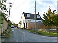
4
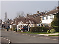
New houses in Wendlebury
A close off the road through the village.
Image: © David Hawgood
Taken: 27 Mar 2007
0.04 miles
5
'The Lion at Wendlebury'
There is an OS benchmark Image on the near corner, road face, of the pub
Image: © Roger Templeman
Taken: 23 Sep 2016
0.05 miles
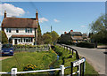
6
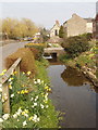
Stream by village street, Wendlebury
In this part of the village, front gardens with flowers run down to the stream along the street. Beyond is the Red Lion, a good pub for lunch if you are hungry - I had a steak pudding with a big pile of vegetables.
Image: © David Hawgood
Taken: 27 Mar 2007
0.05 miles
7
Red Lion
Red Lion pub opposite Church Lane
Image: © Shaun Ferguson
Taken: 7 Feb 2010
0.06 miles
8
Wendlebury
Looking northeast over the humped bridge towards the Red Lion public house. Dawn, on a wet morning.
Image: © Roger May
Taken: 21 May 2006
0.09 miles
9
Wendlebury, former school
On Church Lane, dated 1850; now residential.
Image: © Mike Faherty
Taken: 1 Oct 2011
0.09 miles
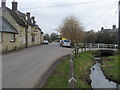
10
Corner of Church Lane
Looking North-east along Wendlebury village street.
The little stream looks placid enough, but has caused property flooding on several occasions. The Environment Agency has installed a flood warning station a couple of hundred metres along from this scene.
Image: © Des Blenkinsopp
Taken: 21 Apr 2010
0.10 miles