IMAGES TAKEN NEAR TO
Oxford Road, BICESTER, OX25 2NY
Introduction
This page details the photographs taken nearby to Oxford Road, OX25 2NY by members of the Geograph project.
The Geograph project started in 2005 with the aim of publishing, organising and preserving representative images for every square kilometre of Great Britain, Ireland and the Isle of Man.

There are currently over 7.5m images from over14,400 individuals and you can help contribute to the project by visiting https://www.geograph.org.uk
Image Map
Images are licensed for reuse under creativecommons.org/licenses/by-sa/2.0
Notes
- Clicking on the map will re-center to the selected point.
- The higher the marker number, the further away the image location is from the centre of the postcode.
Image Listing (9 Images Found)
Images are licensed for reuse under creativecommons.org/licenses/by-sa/2.0
Image
Details
Distance
1
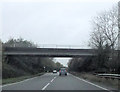
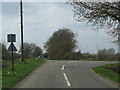
Minor road crossing A41
Just west of Bicester
Image: © John Firth
Taken: 29 Oct 2014
0.04 miles

5
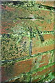
Benchmark on brick cowshed at Lodge Farm
Ordnance Survey cut mark benchmark described on the Bench Mark Database at http://www.bench-marks.org.uk/bm79259
Image: © Roger Templeman
Taken: 23 Sep 2016
0.13 miles
6
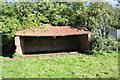
Brick cowshed beside telecoms mast at Lodge Farm
There is an OS benchmark Image on the right hand side of the shed
Image: © Roger Templeman
Taken: 23 Sep 2016
0.13 miles
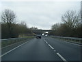
7
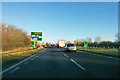
A41 towards Bicester
Approaching the first roundabout of Bicester, greatly enlarged in recent times.
Image: © Robin Webster
Taken: 28 Dec 2017
0.16 miles