IMAGES TAKEN NEAR TO
Merton, BICESTER, OX25 2ND
Introduction
This page details the photographs taken nearby to OX25 2ND by members of the Geograph project.
The Geograph project started in 2005 with the aim of publishing, organising and preserving representative images for every square kilometre of Great Britain, Ireland and the Isle of Man.

There are currently over 7.5m images from over14,400 individuals and you can help contribute to the project by visiting https://www.geograph.org.uk
Image Map
Images are licensed for reuse under creativecommons.org/licenses/by-sa/2.0
Notes
- Clicking on the map will re-center to the selected point.
- The higher the marker number, the further away the image location is from the centre of the postcode.
Image Listing (9 Images Found)
Images are licensed for reuse under creativecommons.org/licenses/by-sa/2.0
Image
Details
Distance
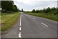
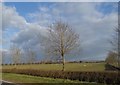
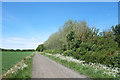
3
Road to Astley Bridge Farm
A neat avenue, also a bridleway, is the access to Astley Bridge Farm.
Image: © Des Blenkinsopp
Taken: 18 May 2020
0.05 miles
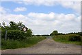
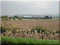
4
Gate to Merton Grounds
A very well maintained farm road and bridleway.
Image: © Des Blenkinsopp
Taken: 18 May 2020
0.09 miles
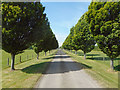
6
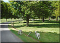
The lambs are getting out
Despite all the grass in the field, these two have decided the stuff by the road is better so they'll go through where the fence is knocked over. One is half in and half out and deciding which way to run, and the one in front hasn't noticed me yet, the grass is so delicious.
Along the drive at Astley Bridge Farm which is also a bridleway..
Image: © Des Blenkinsopp
Taken: 18 May 2020
0.16 miles
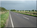
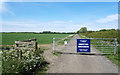
9
Langford Lane
Farm road and bridleway.
Image: © Des Blenkinsopp
Taken: 18 May 2020
0.24 miles