IMAGES TAKEN NEAR TO
Ploughley Road, BICESTER, OX25 2JS
Introduction
This page details the photographs taken nearby to Ploughley Road, OX25 2JS by members of the Geograph project.
The Geograph project started in 2005 with the aim of publishing, organising and preserving representative images for every square kilometre of Great Britain, Ireland and the Isle of Man.

There are currently over 7.5m images from over14,400 individuals and you can help contribute to the project by visiting https://www.geograph.org.uk
Image Map
Images are licensed for reuse under creativecommons.org/licenses/by-sa/2.0
Notes
- Clicking on the map will re-center to the selected point.
- The higher the marker number, the further away the image location is from the centre of the postcode.
Image Listing (15 Images Found)
Images are licensed for reuse under creativecommons.org/licenses/by-sa/2.0
Image
Details
Distance
1
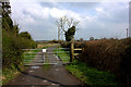
Path to Little Wretchwick Farm
At the A41 end.
Image: © Robert Eva
Taken: 23 Mar 2017
0.07 miles
2

House opposite Wretchwick Farm
There is development work going on behind this property. Possibly, this is the warehouse development that the banner refers to.
Image: © Robert Eva
Taken: 23 Mar 2017
0.07 miles
5

Railway line at Defence Storage and Distribution Centre, Bicester
DSDC Bicester is the Centre for the distribution of the UK's Defence non-explosive material, handling over 1 million tonnes of material each year.
Image: © Jon S
Taken: 10 Oct 2005
0.12 miles
6
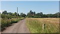
Path heading to the A41
Path from Little Wretchwick Farm heading to the A41
Image: © Shaun Ferguson
Taken: 3 Jul 2019
0.12 miles
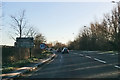
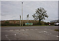
7
Entrance to the MOD Storage and Distribution Centre at Bicester
Image: © Steve Daniels
Taken: 22 Feb 2010
0.14 miles
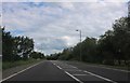
8

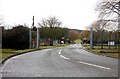
The road from Ambrosden meets the A41
Image: © Sarah Charlesworth
Taken: 22 Mar 2010
0.15 miles
10
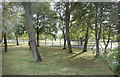
Wretchwick Spinney
The top end of a small line of woodland in between the A41 and a military storage depot.
Image: © Des Blenkinsopp
Taken: 14 Sep 2019
0.19 miles