IMAGES TAKEN NEAR TO
Silibaravi Drive, BICESTER, OX25 2AX
Introduction
This page details the photographs taken nearby to Silibaravi Drive, OX25 2AX by members of the Geograph project.
The Geograph project started in 2005 with the aim of publishing, organising and preserving representative images for every square kilometre of Great Britain, Ireland and the Isle of Man.

There are currently over 7.5m images from over14,400 individuals and you can help contribute to the project by visiting https://www.geograph.org.uk
Image Map
Images are licensed for reuse under creativecommons.org/licenses/by-sa/2.0
Notes
- Clicking on the map will re-center to the selected point.
- The higher the marker number, the further away the image location is from the centre of the postcode.
Image Listing (19 Images Found)
Images are licensed for reuse under creativecommons.org/licenses/by-sa/2.0
Image
Details
Distance
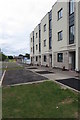
1
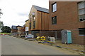
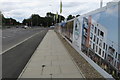
Individual housing and construction on Roberts Drive
Image: © Philip Jeffrey
Taken: 21 Jul 2019
0.03 miles
4
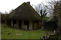
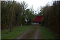
Wretchwick Lodge
This is hidden behind a fence off the A41.
Image: © Robert Eva
Taken: 23 Mar 2017
0.07 miles
6
Hoardings and traffic lights on the way out of Graven Hill
Image: © Philip Jeffrey
Taken: 21 Jul 2019
0.09 miles
7
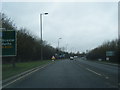
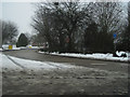
A41 towards Aylesbury
Leaving Bicester behind.
Image: © Robin Webster
Taken: 28 Dec 2017
0.09 miles
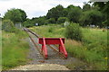
8
End of the path from Middle Wretchwick farm
Here is where the path meets the A41 road and any illusion of rural peace is shattered.
Image: © Robert Eva
Taken: 23 Mar 2017
0.10 miles
9
The exit to Bicester on the A41
Turn right
Image: © David Howard
Taken: 20 Mar 2016
0.10 miles
10
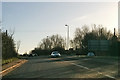
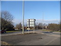
Gravenhill North Road junction with A41
First roundabout on entering Bicester on westbound A41
Image: © John Firth
Taken: 28 Dec 2010
0.11 miles