IMAGES TAKEN NEAR TO
Cornflower Way, BICESTER, OX25 2AF
Introduction
This page details the photographs taken nearby to Cornflower Way, OX25 2AF by members of the Geograph project.
The Geograph project started in 2005 with the aim of publishing, organising and preserving representative images for every square kilometre of Great Britain, Ireland and the Isle of Man.

There are currently over 7.5m images from over14,400 individuals and you can help contribute to the project by visiting https://www.geograph.org.uk
Image Map
Images are licensed for reuse under creativecommons.org/licenses/by-sa/2.0
Notes
- Clicking on the map will re-center to the selected point.
- The higher the marker number, the further away the image location is from the centre of the postcode.
Image Listing (45 Images Found)
Images are licensed for reuse under creativecommons.org/licenses/by-sa/2.0
Image
Details
Distance
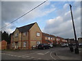
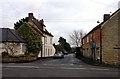
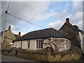
4
New houses on Merton Road
The design is anything but new but the construction is
Image: © David Howard
Taken: 20 Mar 2016
0.10 miles
6
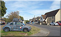
Old Car on the Corner
Parked on the verge facing onto Merton Road.
It looks like an old VW Beetle kitted out to cross the Sahara or something.
Image: © Des Blenkinsopp
Taken: 14 Sep 2019
0.10 miles
9
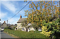
Crab Apple Tree, Ambrosden
A garden tree laden with fruit along Old Arncott Road.
Image: © Des Blenkinsopp
Taken: 14 Sep 2019
0.10 miles
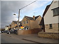
10
House on the corner of Merton Road and Old Ambrosden Road
Image: © David Howard
Taken: 20 Mar 2016
0.12 miles