IMAGES TAKEN NEAR TO
Weir Lane, BICESTER, OX25 1UL
Introduction
This page details the photographs taken nearby to Weir Lane, OX25 1UL by members of the Geograph project.
The Geograph project started in 2005 with the aim of publishing, organising and preserving representative images for every square kilometre of Great Britain, Ireland and the Isle of Man.

There are currently over 7.5m images from over14,400 individuals and you can help contribute to the project by visiting https://www.geograph.org.uk
Image Map
Images are licensed for reuse under creativecommons.org/licenses/by-sa/2.0
Notes
- Clicking on the map will re-center to the selected point.
- The higher the marker number, the further away the image location is from the centre of the postcode.
Image Listing (23 Images Found)
Images are licensed for reuse under creativecommons.org/licenses/by-sa/2.0
Image
Details
Distance
1
Leaving Blackthorn through White Gates
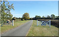
Coming into the top end of Blackthorn village you pass a pair of smart white gates. Image You go on past a handful of houses and after 100 metres or so you leave the village again via another set of white gates.
Up to the end, right onto Station Road, along a bit and you come into the bottom end of Blackthorn through, guess what, some more white gates. Image Beautifully mown grass verges all the way.
Somebody round here takes a lot of trouble. It looks very neat.
Image: © Des Blenkinsopp
Taken: 14 Sep 2019
0.05 miles
2
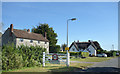
Blackthorn Village Sign
Outside Weir Farm Cottages. Blackthorn is a very well kept village, with several of these white gate things and carefully mown roadside verges.
Image: © Des Blenkinsopp
Taken: 14 Sep 2019
0.07 miles
5
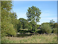
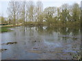
Weir Pond in a Dry Summer
The pond is looking rather depleted compared with this well filled springtime picture. Image
Image: © Des Blenkinsopp
Taken: 14 Sep 2019
0.12 miles
6
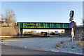
Railway bridge on the A41, Blackthorn
The old Blackthorn Station used to be on the right by the bridge. It closed on 8th of June 1953 https://en.wikipedia.org/wiki/Blackthorn_railway_station
Image: © David Howard
Taken: 8 Jun 2019
0.12 miles
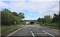
7
Station Road approaching the A41
Blackthorn station was just to the left of the railway bridge. It was late opening, early closing - 1910 to 1953.
Image: © Robin Webster
Taken: 4 Dec 2016
0.13 miles
8
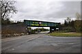
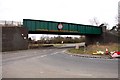
Railway bridge over the A41
This low bridge over the A41 at Blackthorn carries the Chiltern Railways line from Princes Risborough to Banbury. Blackthorn Station was on the left, but was closed in 1953. The area to the right is used for turning over height vehicles that cannot get under the bridge. With overheight warning gauges, signs and all the yellow signage on the bridge there will hopefully be no 'bridge bashes' here.
Image: © Bob Walters
Taken: 6 Nov 2021
0.15 miles
9
Blackthorn Bridge over the A41
Looking towards Bicester. The railway runs from Marylebone to Birmingham.
Image: © Steve Daniels
Taken: 31 Mar 2013
0.15 miles
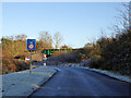
10
Low bridge on A41
The Great Western route to the north crosses bridge NAJ3/18.
Image: © Robin Webster
Taken: 4 Dec 2016
0.16 miles