IMAGES TAKEN NEAR TO
Blackthorn Close, BICESTER, OX25 1TR
Introduction
This page details the photographs taken nearby to Blackthorn Close, OX25 1TR by members of the Geograph project.
The Geograph project started in 2005 with the aim of publishing, organising and preserving representative images for every square kilometre of Great Britain, Ireland and the Isle of Man.

There are currently over 7.5m images from over14,400 individuals and you can help contribute to the project by visiting https://www.geograph.org.uk
Image Map
Images are licensed for reuse under creativecommons.org/licenses/by-sa/2.0
Notes
- Clicking on the map will re-center to the selected point.
- The higher the marker number, the further away the image location is from the centre of the postcode.
Image Listing (20 Images Found)
Images are licensed for reuse under creativecommons.org/licenses/by-sa/2.0
Image
Details
Distance
5
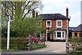
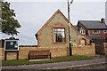
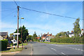
The former Rose & Crown
The Rose & Crown on Thame Road has been converted into a house. The pub was a former Morrells house.
Image: © Steve Daniels
Taken: 5 May 2013
0.09 miles
8
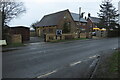
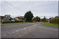
Thame Road, Blackthorn
A lot nearer to Bicester than to Thame, but it does end up there eventually.
Image: © Des Blenkinsopp
Taken: 14 Sep 2019
0.10 miles