IMAGES TAKEN NEAR TO
Harper Close, BICESTER, OX25 1QW
Introduction
This page details the photographs taken nearby to Harper Close, OX25 1QW by members of the Geograph project.
The Geograph project started in 2005 with the aim of publishing, organising and preserving representative images for every square kilometre of Great Britain, Ireland and the Isle of Man.

There are currently over 7.5m images from over14,400 individuals and you can help contribute to the project by visiting https://www.geograph.org.uk
Image Map
Images are licensed for reuse under creativecommons.org/licenses/by-sa/2.0
Notes
- Clicking on the map will re-center to the selected point.
- The higher the marker number, the further away the image location is from the centre of the postcode.
Image Listing (8 Images Found)
Images are licensed for reuse under creativecommons.org/licenses/by-sa/2.0
Image
Details
Distance
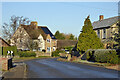
3
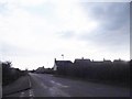
New houses in Arncott
In 2011 the area where all the houses are except the one on the right was a field.
Image: © David Howard
Taken: 20 Mar 2016
0.12 miles
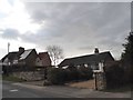
4
Rail Crossing near Arncott
Crossing for the Depot Railway at Arncott.
Image: © Jackie Harman
Taken: 17 Jul 2006
0.14 miles
6
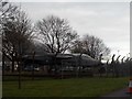
Former school, Arncott
A remarkably small building, late Victorian, now business premises.
Image: © Robin Webster
Taken: 4 Dec 2016
0.19 miles
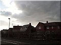
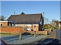
8
Houses on Norris Road, Upper Arncott
The house with the solar panels recently added the extension on the right.
Image: © David Howard
Taken: 20 Mar 2016
0.23 miles