IMAGES TAKEN NEAR TO
Piddington, BICESTER, OX25 1QG
Introduction
This page details the photographs taken nearby to OX25 1QG by members of the Geograph project.
The Geograph project started in 2005 with the aim of publishing, organising and preserving representative images for every square kilometre of Great Britain, Ireland and the Isle of Man.

There are currently over 7.5m images from over14,400 individuals and you can help contribute to the project by visiting https://www.geograph.org.uk
Image Map
Images are licensed for reuse under creativecommons.org/licenses/by-sa/2.0
Notes
- Clicking on the map will re-center to the selected point.
- The higher the marker number, the further away the image location is from the centre of the postcode.
Image Listing (7 Images Found)
Images are licensed for reuse under creativecommons.org/licenses/by-sa/2.0
Image
Details
Distance
1
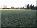
Middle Cow Leys Farm
From the footpath to the A41 looking across to Middle Cow Leys Farm
Image: © Shaun Ferguson
Taken: 21 Feb 2009
0.05 miles
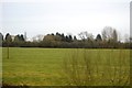
3
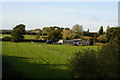
Farm Buildings
Looking NNW from the railway bridge on the road from Piddington to the A41.
Image: © Mark Edwards
Taken: 7 Oct 2006
0.12 miles
4
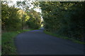
The Road to Piddington
A lovely quiet lane despite its proximity to the busy A41.
Image: © Mark Edwards
Taken: 7 Oct 2006
0.16 miles
5
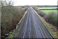
The line to Bicester North
The Chiltern Line runs from London Marylebone to Birmingham Snow Hill.
Image: © Steve Daniels
Taken: 13 Jan 2015
0.18 miles
6
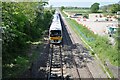
Chiltern Railways Class 165 No. 165035 near Piddington
Chiltern Railways Class 165 No. 165035 heading northwards towards Bicester near Piddington. The works on the right are part of embankment strengthening along this stretch of line.
Image: © Bob Walters
Taken: 31 May 2021
0.23 miles
7
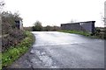
The road crosses the Chiltern Line near Piddington
Image: © Steve Daniels
Taken: 13 Jan 2015
0.25 miles