IMAGES TAKEN NEAR TO
The Homestead, WOODSTOCK, OX20 1XA
Introduction
This page details the photographs taken nearby to The Homestead, OX20 1XA by members of the Geograph project.
The Geograph project started in 2005 with the aim of publishing, organising and preserving representative images for every square kilometre of Great Britain, Ireland and the Isle of Man.

There are currently over 7.5m images from over14,400 individuals and you can help contribute to the project by visiting https://www.geograph.org.uk
Image Map (Loading...)


Getting Data...Please wait
Leaflet Map data © OpenStreetMap
Images are licensed for reuse under creativecommons.org/licenses/by-sa/2.0
Notes
- Clicking on the map will re-center to the selected point.
- The higher the marker number, the further away the image location is from the centre of the postcode.
Image Listing (58 Images Found)
Images are licensed for reuse under creativecommons.org/licenses/by-sa/2.0
Image
Details
Distance
1
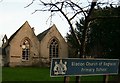
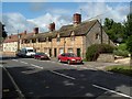
Bladon Primary School
The attractive buildings of Bladon Primary School.
Image: © Kurt C
Taken: 4 Feb 2007
0.03 miles
2
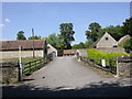
Bladon, Home Farm
On Grove Road; suppliers of wood, hay and straw, no doubt with other more traditional farming activities.
Image: © Mike Faherty
Taken: 16 Aug 2010
0.03 miles
3

Milestone on pavement of Grove Road
There is a front view of the milestone at Image and a picture showing the Ordnance Survey benchmark on its top at Image
Image: © Roger Templeman
Taken: 27 Oct 2014
0.04 miles
4
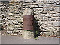
Bladon, milestone
Showing detail of Image
Milestone Society details:
Metal plate attached to stone post by the A4095, in parish of BLADON (WEST OXFORDSHIRE District), Grove Road; by No.49, Hensington, on footpath beside stone wall, on North side of road. Witney pillar & iron plate, erected by the Barrington & Campsfield turnpike trust in the 19th century.
Inscription reads:-
WOODFLOCK
1 MILE
Carved benchmark with rivet on top.
Milestone Society National ID: OX_WSWT01
Image: © Mike Faherty
Taken: 16 Aug 2010
0.04 miles
5
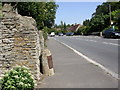
Bladon, milestone
On Grove Road, North of the village centre. The stone has a modern, replica plate, giving the distance to "WOODFLOCK", 1 mile; WOODSTOCK is one mile away, so confusion must have arisen with a person, without local knowledge, misreading plates with similar legends, which used an old-fashioned "f" for "s". For detail, see Image
Image: © Mike Faherty
Taken: 16 Aug 2010
0.04 miles
6

Milestone on pavement of Grove Road
The stone is 1 mile from Woodstock with quaint spelling of the town name on the metal plate. There is an OS benchmark Image on the top of the stone which is shown in context view at Image
Image: © Roger Templeman
Taken: 27 Oct 2014
0.04 miles
7

Milestone with benchmark on top, Grove Road
Ordnance Survey rivet benchmark described on the Bench Mark Database at http://www.bench-marks.org.uk/bm61529
Image: © Roger Templeman
Taken: 27 Oct 2014
0.04 miles
9
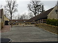
Office development at Home Farm
Selling off of land for housing and offices is transforming the towns and villages surrounding the Blenheim Palace estate.
Image: © John M
Taken: 24 Mar 2018
0.05 miles
10
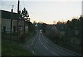
Bladon (A4095 at dusk)
The A4095 through Bladon at dusk. Bladon is a stunning village with a very rich history, and many picturesque buildings.
Image: © Kurt C
Taken: 4 Feb 2007
0.06 miles