IMAGES TAKEN NEAR TO
Crecy Walk, WOODSTOCK, OX20 1UT
Introduction
This page details the photographs taken nearby to Crecy Walk, OX20 1UT by members of the Geograph project.
The Geograph project started in 2005 with the aim of publishing, organising and preserving representative images for every square kilometre of Great Britain, Ireland and the Isle of Man.

There are currently over 7.5m images from over14,400 individuals and you can help contribute to the project by visiting https://www.geograph.org.uk
Image Map
Images are licensed for reuse under creativecommons.org/licenses/by-sa/2.0
Notes
- Clicking on the map will re-center to the selected point.
- The higher the marker number, the further away the image location is from the centre of the postcode.
Image Listing (60 Images Found)
Images are licensed for reuse under creativecommons.org/licenses/by-sa/2.0
Image
Details
Distance
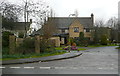
1
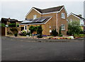
Crecy Walk, Woodstock
Viewed from The Covert.
Image: © Jaggery
Taken: 20 Jun 2015
0.02 miles
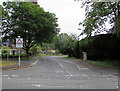
2
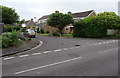
Junction of Princes Ride and Crecy Walk, Woodstock
Looking across Princes Ride. The name sign next to
a tree shows CRECY WALK LEADING TO THE COVERT.
Image: © Jaggery
Taken: 20 Jun 2015
0.05 miles
3
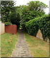
Willoughby Way, Woodstock
Path north from Princes Ride towards Recreation Road.
Image: © Jaggery
Taken: 20 Jun 2015
0.07 miles
4
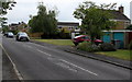
Princes Ride, Woodstock
Looking ENE from the corner of Crecy Walk.
Image: © Jaggery
Taken: 20 Jun 2015
0.07 miles
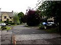
5
Churchill Close
A group of about 10 houses, off the A44, opposite Blenheim Park, where Sir Winston Churchill was born. Shakespeare's Way passes here. The bard would not have known about Churchill, except as the name of a nearby village.
Image: © Graham Horn
Taken: 16 Mar 2013
0.09 miles
6

Cadogan Park, Woodstock
On the north side of the A44 Oxford Road. Looking along the road named Cadogan Park towards Princes Ride.
Image: © Jaggery
Taken: 20 Jun 2015
0.09 miles
7
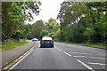
A44 Oxford Road
Approaching Woodstock.
Image: © Robin Webster
Taken: 11 Aug 2019
0.10 miles
8
Churchill Gate, Woodstock
Houses on the north side of the A44 Oxford Road.
Image: © Jaggery
Taken: 20 Jun 2015
0.10 miles
9
Cadogan Park, Woodstock
The road named Cadogan Park is on the north side of the A44 Oxford Road.
Image: © Jaggery
Taken: 20 Jun 2015
0.10 miles
10
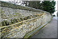
Wall at Blenheim Park
The estate wall, to the left, was built in the 1720s. Here, a modern extension has been tied in well with the original. Shakespeare's Way passes here.
Image: © Graham Horn
Taken: 16 Mar 2013
0.10 miles