IMAGES TAKEN NEAR TO
WOODSTOCK, OX20 1QJ
Introduction
This page details the photographs taken nearby to OX20 1QJ by members of the Geograph project.
The Geograph project started in 2005 with the aim of publishing, organising and preserving representative images for every square kilometre of Great Britain, Ireland and the Isle of Man.

There are currently over 7.5m images from over14,400 individuals and you can help contribute to the project by visiting https://www.geograph.org.uk
Image Map
Images are licensed for reuse under creativecommons.org/licenses/by-sa/2.0
Notes
- Clicking on the map will re-center to the selected point.
- The higher the marker number, the further away the image location is from the centre of the postcode.
Image Listing (8 Images Found)
Images are licensed for reuse under creativecommons.org/licenses/by-sa/2.0
Image
Details
Distance
1
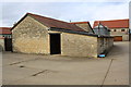
Buildings at Perdiswell Farm, Shipton Road
There is an OS benchmark Image on a stone in the wall of the building left of the black door
Image: © Roger Templeman
Taken: 23 Oct 2014
0.01 miles
2
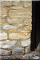
Benchmark at Perdiswell Farm
Ordnance Survey cut mark benchmark described on the Bench Mark Database at http://www.bench-marks.org.uk/bm61559
Image: © Roger Templeman
Taken: 23 Oct 2014
0.01 miles
5
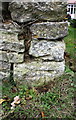
Benchmark on 'Four Winds' wall
Ordnance Survey cut mark benchmark described on the Bench Mark Database at http://www.bench-marks.org.uk/bm61558
Image: © Roger Templeman
Taken: 23 Oct 2014
0.18 miles
6
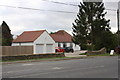
'Four Winds', Upper Campsfield Road
There is an OS benchmark Image at the bottom of the dry stone wall at its right hand end near the 'fresh eggs' sign
Image: © Roger Templeman
Taken: 23 Oct 2014
0.18 miles
7
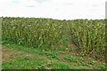
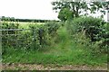
Footpath through the beans to Upper Campsfield Road
Image: © Philip Jeffrey
Taken: 21 Jul 2024
0.19 miles
8
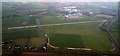
London Oxford Airport
This picture was taken from a Cessna 172 at 2,000ft above sea level.
Image: © Richard Smith
Taken: 7 Apr 2011
0.24 miles