IMAGES TAKEN NEAR TO
Glyme Close, WOODSTOCK, OX20 1LB
Introduction
This page details the photographs taken nearby to Glyme Close, OX20 1LB by members of the Geograph project.
The Geograph project started in 2005 with the aim of publishing, organising and preserving representative images for every square kilometre of Great Britain, Ireland and the Isle of Man.

There are currently over 7.5m images from over14,400 individuals and you can help contribute to the project by visiting https://www.geograph.org.uk
Image Map (Loading...)


Getting Data...Please wait
Leaflet Map data © OpenStreetMap
Images are licensed for reuse under creativecommons.org/licenses/by-sa/2.0
Notes
- Clicking on the map will re-center to the selected point.
- The higher the marker number, the further away the image location is from the centre of the postcode.
Image Listing (120 Images Found)
Images are licensed for reuse under creativecommons.org/licenses/by-sa/2.0
Image
Details
Distance
1
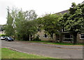
Tree-lined Glyme Close, Woodstock
An entrance http://www.geograph.org.uk/photo/4537902 to Woodstock Watermeadows is behind the camera.
Image: © Jaggery
Taken: 20 Jun 2015
0.03 miles
2
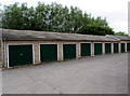
Glyme Close lockup garages, Woodstock
Near this http://www.geograph.org.uk/photo/4537902 entrance to Woodstock Watermeadows.
Image: © Jaggery
Taken: 20 Jun 2015
0.04 miles
3
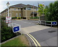
Entrance to the Owen Mumford site in Woodstock
From Green Lane. Their website states that Owen Mumford is a global
industry leader in medical device design and manufacturing. Maximum speed 5mph.
Image: © Jaggery
Taken: 20 Jun 2015
0.04 miles
4
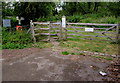
Glyme Close entrance to Woodstock Watermeadows
The Please notice on the gate asks you to respect the flora and fauna,
not let your dog foul the footpath, and to take your litter home.
The watermeadows provide a valuable habitat for birds, small mammals and plants, from small aquatic species to mature trees. They cover 5.5 hectares of land on the flood plain of the River Glyme, easily accessible to the public as an area of tranquillity. The watermeadows are bounded on the north by the millstream which carries most of the water under the A44 into Blenheim Lake by the Seven Arches bridge. The southern boundary is the River Glyme. The watermeadows are frequently flooded, especially in winter.
Image: © Jaggery
Taken: 20 Jun 2015
0.04 miles
5
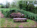
Log bench and wooden table in Woodstock Watermeadows
Near the Glyme Close side of the watermeadows.
Image: © Jaggery
Taken: 20 Jun 2015
0.06 miles
6
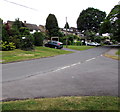
Junction of Glyme Close and Brook Hill, Woodstock
From the southern end of Glyme Close.
Image: © Jaggery
Taken: 20 Jun 2015
0.06 miles
7
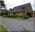
Kingfisher Court, Woodstock
Modern flats at 31 Green Lane.
Image: © Jaggery
Taken: 20 Jun 2015
0.07 miles
8
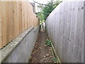
Narrow path from Green Lane, Woodstock
Passes between houses to open field.
Image: © Liz Stone
Taken: 8 Oct 2011
0.07 miles
9
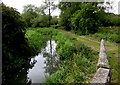
River and path in Woodstock Watermeadows
The river is the Glyme, here streamlike, though nearby notices warn that the meadows are prone to flooding.
Image: © Jaggery
Taken: 20 Jun 2015
0.08 miles
10
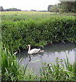
Swan and cygnet on the River Glyme, Woodstock Watermeadows
Viewed in mid June 2015. My walking companion said that it is unusual to see a swan with only one cygnet.
Image: © Jaggery
Taken: 20 Jun 2015
0.08 miles