IMAGES TAKEN NEAR TO
Green Lane, WOODSTOCK, OX20 1JZ
Introduction
This page details the photographs taken nearby to Green Lane, OX20 1JZ by members of the Geograph project.
The Geograph project started in 2005 with the aim of publishing, organising and preserving representative images for every square kilometre of Great Britain, Ireland and the Isle of Man.

There are currently over 7.5m images from over14,400 individuals and you can help contribute to the project by visiting https://www.geograph.org.uk
Image Map (Loading...)


Getting Data...Please wait
Leaflet Map data © OpenStreetMap
Images are licensed for reuse under creativecommons.org/licenses/by-sa/2.0
Notes
- Clicking on the map will re-center to the selected point.
- The higher the marker number, the further away the image location is from the centre of the postcode.
Image Listing (93 Images Found)
Images are licensed for reuse under creativecommons.org/licenses/by-sa/2.0
Image
Details
Distance
1
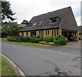
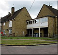
Kingfisher Court, Woodstock
Modern flats at 31 Green Lane.
Image: © Jaggery
Taken: 20 Jun 2015
0.03 miles
2
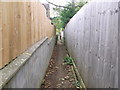
Narrow path from Green Lane, Woodstock
Passes between houses to open field.
Image: © Liz Stone
Taken: 8 Oct 2011
0.03 miles
3
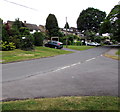
Junction of Glyme Close and Brook Hill, Woodstock
From the southern end of Glyme Close.
Image: © Jaggery
Taken: 20 Jun 2015
0.07 miles
4
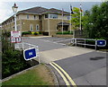
Entrance to the Owen Mumford site in Woodstock
From Green Lane. Their website states that Owen Mumford is a global
industry leader in medical device design and manufacturing. Maximum speed 5mph.
Image: © Jaggery
Taken: 20 Jun 2015
0.08 miles
5
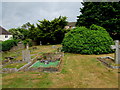
NE corner of Hensington Road Cemetery in Woodstock
This is one of two cemeteries in Woodstock. The other one is in Green Lane.
Image: © Jaggery
Taken: 20 Jun 2015
0.09 miles
6
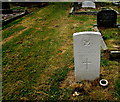
Woodstock War Grave
The Hensington Road Cemetery grave of Staff Serjeant 7595600 William James Charlett
of REME (Royal Electrical and Mechanical Engineers). He died on May 19th 1944 aged 37.
Image: © Jaggery
Taken: 20 Jun 2015
0.09 miles
7
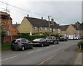
Green Lane, Woodstock
Viewed from near the Hensington Road junction, looking NW.
Image: © Jaggery
Taken: 20 Jun 2015
0.10 miles
8
Corner of Green Lane and Churchill Close, Woodstock
Viewed across Green Lane.
Image: © Jaggery
Taken: 20 Jun 2015
0.10 miles
9
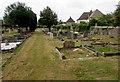
Northern edge of Hensington Road Cemetery, Woodstock
This is one of two cemeteries in Woodstock. The other one is Woodstock Lawn Cemetery, http://www.geograph.org.uk/photo/4537963 accessed from Green Lane.
Image: © Jaggery
Taken: 20 Jun 2015
0.11 miles
10
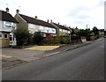
Green Lane houses, Woodstock
Looking SE towards Hensington Road.
Image: © Jaggery
Taken: 20 Jun 2015
0.11 miles