IMAGES TAKEN NEAR TO
Church Street, WOODSTOCK, OX20 1EB
Introduction
This page details the photographs taken nearby to Church Street, OX20 1EB by members of the Geograph project.
The Geograph project started in 2005 with the aim of publishing, organising and preserving representative images for every square kilometre of Great Britain, Ireland and the Isle of Man.

There are currently over 7.5m images from over14,400 individuals and you can help contribute to the project by visiting https://www.geograph.org.uk
Image Map
Images are licensed for reuse under creativecommons.org/licenses/by-sa/2.0
Notes
- Clicking on the map will re-center to the selected point.
- The higher the marker number, the further away the image location is from the centre of the postcode.
Image Listing (65 Images Found)
Images are licensed for reuse under creativecommons.org/licenses/by-sa/2.0
Image
Details
Distance
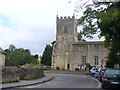
1
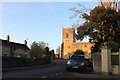
Church Street, Wootton
Looking towards St Mary's Church
Image: © David Howard
Taken: 21 Jan 2020
0.01 miles
3
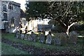
Old headstones
Headstones near the path at St Mary Wootton
Image: © Bill Nicholls
Taken: 18 Jan 2023
0.02 miles
4
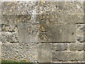
Bench Mark, Wotton Church
A clean cut bench mark on the angled buttress supporting the tower wall. Had to zoom in on this one as Wotton church yard was full of wedding guests.
Image: © Michael Trolove
Taken: 22 May 2010
0.02 miles
5
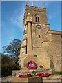
Wootton: the war memorial on Armistice Day
The war memorial stands in the grounds of the parish church of St. Mary the Virgin, and is decorated with commemorative poppy wreaths on this November 11.
Image: © Chris Downer
Taken: 11 Nov 2016
0.02 miles
7
Nineteenth-century benchmark
This benchmark was established between 1850 and 1856 during the First primary levelling of England & Wales, and was levelled with a height of 356.2100 feet [108.5728 metres] above mean sea level (Liverpool datum). It was included as a side level on the Basingstoke to Coventry levelling line. The surveyor's description was "No. 132(b). Wootton Church. Bolt on South side of tower; 3.22 ft. above surface" (Public Abstract p. 238).
Image: © Shantavira
Taken: 28 Oct 2017
0.02 miles
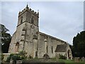
8
St Mary the Virgin Church, Wootton
Historic parish church with 13th century south porch, 14th century chancel and 15th century clerestory. Francis Kilvert, diarist, was married here, 1879.
Image: © Colin Smith
Taken: 21 Aug 2011
0.02 miles
9
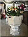
Flowers on the font
Flowers bedeck the font at St Mary Wootton
Image: © Bill Nicholls
Taken: 18 Jan 2023
0.02 miles
10
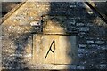
Sundial over the porch
The carvings or the numbers are eroding a little but it still tells the time at St Mary Wootton
Image: © Bill Nicholls
Taken: 18 Jan 2023
0.02 miles