IMAGES TAKEN NEAR TO
Lewisfield Way, WOODSTOCK, OX20 1DF
Introduction
This page details the photographs taken nearby to Lewisfield Way, OX20 1DF by members of the Geograph project.
The Geograph project started in 2005 with the aim of publishing, organising and preserving representative images for every square kilometre of Great Britain, Ireland and the Isle of Man.

There are currently over 7.5m images from over14,400 individuals and you can help contribute to the project by visiting https://www.geograph.org.uk
Image Map (Loading...)


Getting Data...Please wait
Leaflet Map data © OpenStreetMap
Images are licensed for reuse under creativecommons.org/licenses/by-sa/2.0
Notes
- Clicking on the map will re-center to the selected point.
- The higher the marker number, the further away the image location is from the centre of the postcode.
Image Listing (12 Images Found)
Images are licensed for reuse under creativecommons.org/licenses/by-sa/2.0
Image
Details
Distance
1
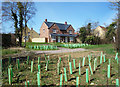
New Houses, New Trees
Part of a new housing development on the eastern edge of Woodstock.
Image: © Des Blenkinsopp
Taken: 5 Apr 2018
0.04 miles
2
Gate on the bridleway to Shipton Slade Cottages
Image: © Philip Jeffrey
Taken: 21 Jul 2024
0.05 miles
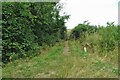
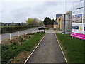
4
New housing on the edge of town
Like every other historic town round here, Woodstock is putting on weight in its old age.
Image: © Des Blenkinsopp
Taken: 5 Apr 2018
0.09 miles
6

Woodstock Outdoor Pool, Shipton Road
Image: © Roger Templeman
Taken: 23 Oct 2014
0.10 miles
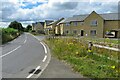
7
Shipton road
Shipton road heading to Woodstock by Marlborough Place development
Image: © Shaun Ferguson
Taken: 2 Apr 2011
0.11 miles

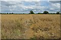
9
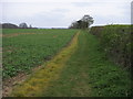
Footpath to Shipston Slade
Footpath from Woodstock to Shipston Slade
Image: © Shaun Ferguson
Taken: 2 Apr 2011
0.13 miles
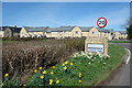
10
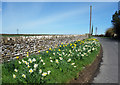
Flowers by the Wall
Springtime along Banbury Road on the edge of Woodstock.
Image: © Des Blenkinsopp
Taken: 5 Apr 2018
0.18 miles