IMAGES TAKEN NEAR TO
Church Lane, BURFORD, OX18 4BA
Introduction
This page details the photographs taken nearby to Church Lane, OX18 4BA by members of the Geograph project.
The Geograph project started in 2005 with the aim of publishing, organising and preserving representative images for every square kilometre of Great Britain, Ireland and the Isle of Man.

There are currently over 7.5m images from over14,400 individuals and you can help contribute to the project by visiting https://www.geograph.org.uk
Image Map
Images are licensed for reuse under creativecommons.org/licenses/by-sa/2.0
Notes
- Clicking on the map will re-center to the selected point.
- The higher the marker number, the further away the image location is from the centre of the postcode.
Image Listing (111 Images Found)
Images are licensed for reuse under creativecommons.org/licenses/by-sa/2.0
Image
Details
Distance
1
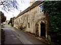
Grade II listed Pytts House, Church Lane, Fulbrook
Probably dating from the mid 16th century, with later alterations.
Grade II listed Pytts Barn is behind the camera. https://www.geograph.org.uk/photo/5659251
Image: © Jaggery
Taken: 16 Jan 2018
0.00 miles
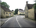
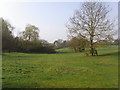
2
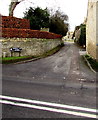
North along Church Lane, Fulbrook
From the A361 along Church Lane towards the Church of St James the Great. https://www.geograph.org.uk/photo/5654326
Image: © Jaggery
Taken: 16 Jan 2018
0.01 miles
3
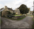
Corner of Dolphin Lane and Church Lane, Fulbrook
The church of St James the Great https://www.geograph.org.uk/photo/5654326 is behind the tree.
Image: © Jaggery
Taken: 16 Jan 2018
0.02 miles
4
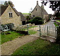
Kissing gate at the northern end of Church Lane, Fulbrook, West Oxfordshire
The gate gives walkers access to the path https://www.geograph.org.uk/photo/5654326 to St James the Great.
Image: © Jaggery
Taken: 16 Jan 2018
0.02 miles
5
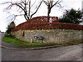
Hedge and stone wall on a Fulbrook corner, West Oxfordshire
On the corner of the A361 and Church Lane. https://www.geograph.org.uk/photo/5659230
Image: © Jaggery
Taken: 16 Jan 2018
0.02 miles
6
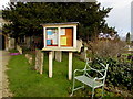
Bench and church noticeboard, Fulbrook, West Oxfordshire
Alongside the entrance path https://www.geograph.org.uk/photo/5654326 to St James the Great.
One of the notices informs would-be lead thieves that churches in this area have roof alarms.
Image: © Jaggery
Taken: 16 Jan 2018
0.02 miles
7
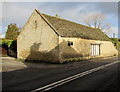
Grade II listed Pytts Barn, Fulbrook
Probably dating from the early 17th century, Pytts Barn is on the corner of Church Lane and the A361, south of Pytts House. https://www.geograph.org.uk/photo/5659264
Image: © Jaggery
Taken: 16 Jan 2018
0.02 miles
8
A361 junction with Church lane , Fulbrook
Image: © Stuart Logan
Taken: 15 Jul 2012
0.03 miles
10
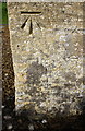
Benchmark on St James the Great Church
Ordnance Survey cut mark benchmark described on the Bench Mark Database at http://www.bench-marks.org.uk/bm55253
Image: © Roger Templeman
Taken: 11 Oct 2016
0.03 miles