IMAGES TAKEN NEAR TO
Abingdon Road, CARTERTON, OX18 3HR
Introduction
This page details the photographs taken nearby to Abingdon Road, OX18 3HR by members of the Geograph project.
The Geograph project started in 2005 with the aim of publishing, organising and preserving representative images for every square kilometre of Great Britain, Ireland and the Isle of Man.

There are currently over 7.5m images from over14,400 individuals and you can help contribute to the project by visiting https://www.geograph.org.uk
Image Map (Loading...)


Getting Data...Please wait
Leaflet Map data © OpenStreetMap
Images are licensed for reuse under creativecommons.org/licenses/by-sa/2.0
Notes
- Clicking on the map will re-center to the selected point.
- The higher the marker number, the further away the image location is from the centre of the postcode.
Image Listing (101 Images Found)
Images are licensed for reuse under creativecommons.org/licenses/by-sa/2.0
Image
Details
Distance

2
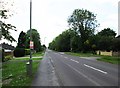
Brize Norton Road, Carterton, Oxon
Looking in the direction of the town centre, where the road meets three others at a crossroads. Near to the crossroads most of the shops, other businesses including the town's two public houses and some restaurants are to be found. In this photograph, the road coming in by the lamp post on the right is Abingdon Road.
Image: © P L Chadwick
Taken: 30 May 2015
0.05 miles
4
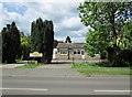
J & P Hayward Carterton Breeding Aviaries, 23 Brize Norton Road, Carterton, Oxon
A specialist pet shop.
Image: © P L Chadwick
Taken: 30 May 2015
0.09 miles
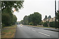
5
Bus stop and shelter, Brize Norton Road, Carterton, Oxon
The stop is served by several bus routes.
Image: © P L Chadwick
Taken: 30 May 2015
0.09 miles
6
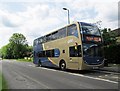
Stagecoach double decker bus on Gold Route S2, Brize Norton Road, Carterton, Oxon
Stagecoach's Gold routes are operated by buses which are to a higher standard than most service buses, particularly in the area of seating comfort. The Gold S2 route runs between Carterton, Witney, Eynsham (via the A40) and the city of Oxford. The route runs frequently from 5.20am to very late at night. Here the bus is seen passing a bus stop and shelter in Brize Norton Road.
Image: © P L Chadwick
Taken: 30 May 2015
0.09 miles
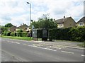
7
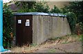
Gas infrastructure, Bovingdon Road, Carterton, Oxon
This small building is part of the local gas supply. It is located under the footbridge over Brize Norton Road. Part of one of the massive supporting pillars for the footbridge can be seen on the extreme left of this photograph.
Image: © P L Chadwick
Taken: 27 Aug 2018
0.10 miles
8
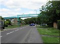
Footbridge over Brize Norton Road, Carterton, Oxon
A footbridge connecting housing estates constructed over the busy Brize Norton Road.
Image: © P L Chadwick
Taken: 30 May 2015
0.10 miles
9
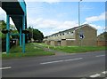
Houses in Bovingdon Road, Carterton, Oxon
These houses appear to be RAF stock, of which there are a large number in the town. The huge structure on the left is part of the footbridge over Brize Norton Road.
Image: © P L Chadwick
Taken: 30 May 2015
0.10 miles
10
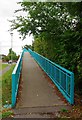
Ramp from Bovingdon Road to footbridge over Brize Norton Road, Carterton, Oxon
A long ramp leading to the footbridge over Brize Norton Road, which is one of the town's major roads. The footbridge and its two ramps are built on quite a large scale. Even with the green paint, it's not a structure you can easily ignore. Part of it takes up a major chunk of this scene:- Image
Image
Image: © P L Chadwick
Taken: 27 Aug 2018
0.10 miles