IMAGES TAKEN NEAR TO
Pemscott Close, BAMPTON, OX18 2QE
Introduction
This page details the photographs taken nearby to Pemscott Close, OX18 2QE by members of the Geograph project.
The Geograph project started in 2005 with the aim of publishing, organising and preserving representative images for every square kilometre of Great Britain, Ireland and the Isle of Man.

There are currently over 7.5m images from over14,400 individuals and you can help contribute to the project by visiting https://www.geograph.org.uk
Image Map (Loading...)


Getting Data...Please wait
Leaflet Map data © OpenStreetMap
Images are licensed for reuse under creativecommons.org/licenses/by-sa/2.0
Notes
- Clicking on the map will re-center to the selected point.
- The higher the marker number, the further away the image location is from the centre of the postcode.
Image Listing (25 Images Found)
Images are licensed for reuse under creativecommons.org/licenses/by-sa/2.0
Image
Details
Distance
1
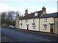
Red Lion House
A former pub on the main street of Alvescot, Oxfordshire.
Image: © Jonathan Billinger
Taken: 19 Dec 2007
0.09 miles

3
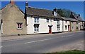
Red Lion House (the former Red Lion), Main Road, Alvescot, Oxon
There used to be three public houses in the village but now there is just the Plough Inn. The Red Lion is one of those that closed some years ago. It is known to have been in business by 1832 and acquired by the Witney brewers Cinch & Co in the late 19th century. It closed in the second half of the 20th century and is now a private residence. The building is believed to incorporate earlier cottages.
Image: © P L Chadwick
Taken: 26 May 2012
0.09 miles
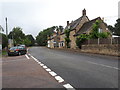

6
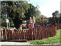
Road junction in Alvescot
Both roads are dead ends, both have bridleways or footpaths at the end. The white sign in the picture advertises Rectory Farm selling free range eggs potatoes and hay.
Image: © andrew auger
Taken: 3 Oct 2009
0.10 miles
9
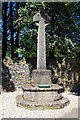
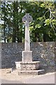
Alvescot War Memorial Cross (1), Main Road, Alvescot, Oxon
The War Memorial is located on a small piece of ground on the corner of Main Road and Mill Lane.
Image
Image: © P L Chadwick
Taken: 26 May 2012
0.12 miles
10
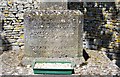
Alvescot War Memorial Cross (2) - inscription, Main Road, Alvescot, Oxon
The inscription reads:- "To the glory of God and in grateful memory of the men of Alvescot who fell in the Great War 1914 - 1918. Greater love hath no man than this".
According to the War Memorial Archive website, the memorial also records the names of ten men who died in the First World War (Great War) and two who died in the Second. It also apparently gives the dates of the latter (1939-1945). If this is correct (and sometimes the WMA isn't) then these details must be on the reverse of the memorial. There is also a Roll of Honour in the local church which has about 70 names. The WMA doesn't know what wars this covers, possibly it could include the Boer War and others?
Image
Image: © P L Chadwick
Taken: 26 May 2012
0.12 miles