IMAGES TAKEN NEAR TO
Weald, BAMPTON, OX18 2ET
Introduction
This page details the photographs taken nearby to OX18 2ET by members of the Geograph project.
The Geograph project started in 2005 with the aim of publishing, organising and preserving representative images for every square kilometre of Great Britain, Ireland and the Isle of Man.

There are currently over 7.5m images from over14,400 individuals and you can help contribute to the project by visiting https://www.geograph.org.uk
Image Map (Loading...)


Getting Data...Please wait
Leaflet Map data © OpenStreetMap
Images are licensed for reuse under creativecommons.org/licenses/by-sa/2.0
Notes
- Clicking on the map will re-center to the selected point.
- The higher the marker number, the further away the image location is from the centre of the postcode.
Image Listing (9 Images Found)
Images are licensed for reuse under creativecommons.org/licenses/by-sa/2.0
Image
Details
Distance
1
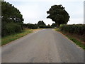
R.A.F. Bampton Castle
Looking across the corner of the fenced area towards White Lodge. The concrete building inside the gate is a pillbox.
Image: © David Luther Thomas
Taken: 14 Apr 2007
0.05 miles
2
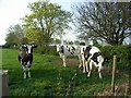
Cattle
In the corner of the field near White Lodge.
Image: © David Luther Thomas
Taken: 14 Apr 2007
0.07 miles
3
Formerly RAF Bampton Castle
Wikipedia says "RAF Bampton Castle is a former non-flying Royal Air Force station in Oxfordshire.
It was the home of No. 2 and No. 81 Signal Units, which dealt with High Frequency radio communications.
The site is now a business centre and all of the antennas have been removed."
That last bit's not strictly true because I can see one in this picture, and there's another over the back out of shot, but compared with the dozens shown on older maps there's not a lot here any more.
As for Bampton Castle, there was a small castle about 1km north of here which was mostly demolished in 1789, with some remains being incorporated into Ham Court, a manor house still standing on the west side of Bampton.
The name was used for the RAF station to avoid confusion as there are several other Bamptons in the country.
Image: © Des Blenkinsopp
Taken: 5 May 2016
0.09 miles
5
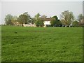
Glebe Farm
From the start of the driveway. Some of the masts from R.A.F. Bampton Castle can be seen.
Image: © David Luther Thomas
Taken: 14 Apr 2007
0.10 miles
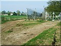
6
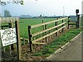
Sign to the Business Centre
This is in the middle of the area marked as RAF Bampton Castle, which older maps show as being covered with radio masts. One or two masts remain inside a small wired off compound with a few huts in it, but most of the area is now farmland. The only sign that it was ever anything else is a network of tracks through the fields which are still in better condition than would be expected for farm tracks.
Some of the remaining buildings may well be in business use, but whatever goes on here now is very low profile.
Image: © Des Blenkinsopp
Taken: 5 May 2016
0.11 miles
8
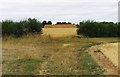
Hayrick in field near Bampton, Oxon
This hayrick (or haystack) has been photographed from some distance away but it is very large, albeit it seems to consist of small bundles of hay piled up. It reminds me a bit of the large hayricks, shaped like giant bread loaves, that I used to see in Wiltshire many decades ago.
Image: © P L Chadwick
Taken: 11 Aug 2018
0.14 miles