IMAGES TAKEN NEAR TO
Shilton Road, CARTERTON, OX18 1EN
Introduction
This page details the photographs taken nearby to Shilton Road, OX18 1EN by members of the Geograph project.
The Geograph project started in 2005 with the aim of publishing, organising and preserving representative images for every square kilometre of Great Britain, Ireland and the Isle of Man.

There are currently over 7.5m images from over14,400 individuals and you can help contribute to the project by visiting https://www.geograph.org.uk
Image Map
Images are licensed for reuse under creativecommons.org/licenses/by-sa/2.0
Notes
- Clicking on the map will re-center to the selected point.
- The higher the marker number, the further away the image location is from the centre of the postcode.
Image Listing (10 Images Found)
Images are licensed for reuse under creativecommons.org/licenses/by-sa/2.0
Image
Details
Distance
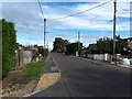
1
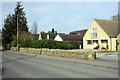
Shilton Road (B4020) passing #26
There is an OS benchmark Image on the milestone beside the wall at the left hand side of the house entrance
Image: © Roger Templeman
Taken: 20 Feb 2017
0.05 miles
2
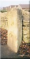
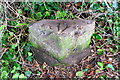
Old Milestone by the B4020, Shilton Road, Carterton
Stone post (plate lost) by the B4020, in parish of CARTERTON (WEST OXFORDSHIRE District), Shilton Road; by No.26, North of garage, between pavement and low stone wall; by drive to bungalows, on North side of road. Radcot iron plate, erected by the Faringdon & Burford turnpike trust in the 19th century.
Inscription once read:- : (Burford / 3 / Faringdon / 8) :
Carved benchmark at lower mid-front.
Milestone Society National ID: OX_FABF08.
Image: © A Rosevear
Taken: 1 Dec 2002
0.05 miles
3
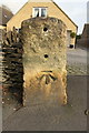
Benchmark on milestone outside #20a Shilton Road
Ordnance Survey cut mark benchmark described on the Bench Mark Database at http://www.bench-marks.org.uk/bm82297
Image: © Roger Templeman
Taken: 20 Feb 2017
0.06 miles
4
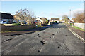
Potholes, Burswin Road
A lot of smart new roads are going in on all the building sites round here, but meanwhile older stuff is left to fall apart.
Image: © Des Blenkinsopp
Taken: 15 Dec 2020
0.09 miles

7
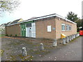
Carterton Telephone Exchange, Oxon
Situated on the B4020 Shilton Road, this redbrick building has the code SMCAR. It provides telephone and broadband services to 6,550 residential and 214 non-residential premises in Carterton plus Alvescot, Black Bourton, Brize Norton and Shilton nearby. Two white BT warning notices can be seen at the front of this TE, whilst a yellow grit salt bin is at the side. The numbering range of this TE is (01993) 84xxxx, the (01993) referring to the Witney group of ten TEs, and its postcode is OX18 1EN.
Image: © David Hillas
Taken: 26 Oct 2018
0.17 miles
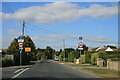
8
Shilton Road (B4020) entering Carterton from the NW
There is an OS benchmark Image on the boundary stone on the verge at the right hand side of the image
Image: © Roger Templeman
Taken: 20 Feb 2017
0.22 miles
9
Swinbrook Road, Carterton
With signs showing weight limit, and that Kilkenny Lane is closed. The yellow sign states access to football club and allotments only.
Image: © andrew auger
Taken: 26 Sep 2009
0.22 miles
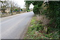
10
Benchmark on boundary stone opposite #82 Shilton Road
Ordnance Survey rivet benchmark described on the Bench Mark Database at http://www.bench-marks.org.uk/bm82339
The stone has the Milestone Society National ID OX_FABF08pb and marks the boundary of Shilton and Casterton parishes
Image: © Roger Templeman
Taken: 20 Feb 2017
0.25 miles