IMAGES TAKEN NEAR TO
Banbury Road, BANBURY, OX17 2HA
Introduction
This page details the photographs taken nearby to Banbury Road, OX17 2HA by members of the Geograph project.
The Geograph project started in 2005 with the aim of publishing, organising and preserving representative images for every square kilometre of Great Britain, Ireland and the Isle of Man.

There are currently over 7.5m images from over14,400 individuals and you can help contribute to the project by visiting https://www.geograph.org.uk
Image Map
Images are licensed for reuse under creativecommons.org/licenses/by-sa/2.0
Notes
- Clicking on the map will re-center to the selected point.
- The higher the marker number, the further away the image location is from the centre of the postcode.
Image Listing (13 Images Found)
Images are licensed for reuse under creativecommons.org/licenses/by-sa/2.0
Image
Details
Distance
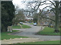
2
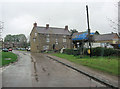
The Three Conies Pub. Thorpe Mandeville
A Hook Norton Establishment.
Image: © Ben Nicholson
Taken: 8 Feb 2006
0.12 miles
4
Millennium Way heading north past some allotments
Image: © Philip Jeffrey
Taken: 8 May 2022
0.12 miles
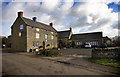
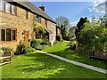
5
The Three Conies
Not the sort of pub one should rabbit-on about but it's 17th C and an old drovers drinking house.English Heritage Building ID: 234502. See also: http://www.britishlistedbuildings.co.uk/en-234502-three-conies-inn-thorpe-mandeville
Image: © Stuart Logan
Taken: 28 Apr 2012
0.12 miles
8
Footpath past the cottages to Banbury Lane
Image: © Philip Jeffrey
Taken: 8 May 2022
0.17 miles
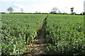
9
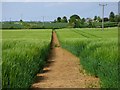
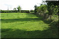
Farmland, Thorpe Mandeville
A footpath through barley to the north of Thenford Hill.
Image: © Andrew Smith
Taken: 23 May 2019
0.19 miles
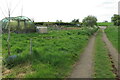
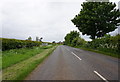
10
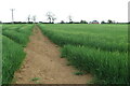
Millennium Way going to Thenford Hill Farm
Image: © Philip Jeffrey
Taken: 8 May 2022
0.22 miles