IMAGES TAKEN NEAR TO
St. Hughs Close, BANBURY, OX16 9JL
Introduction
This page details the photographs taken nearby to St. Hughs Close, OX16 9JL by members of the Geograph project.
The Geograph project started in 2005 with the aim of publishing, organising and preserving representative images for every square kilometre of Great Britain, Ireland and the Isle of Man.

There are currently over 7.5m images from over14,400 individuals and you can help contribute to the project by visiting https://www.geograph.org.uk
Image Map
Images are licensed for reuse under creativecommons.org/licenses/by-sa/2.0
Notes
- Clicking on the map will re-center to the selected point.
- The higher the marker number, the further away the image location is from the centre of the postcode.
Image Listing (49 Images Found)
Images are licensed for reuse under creativecommons.org/licenses/by-sa/2.0
Image
Details
Distance
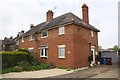
3
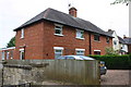
A pair of semis on Springfield Avenue
There is an OS benchmark Image on the side of the left hand house near its front corner (behind the wooden fence).
Image: © Roger Templeman
Taken: 16 May 2014
0.06 miles
4
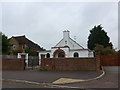
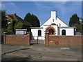
St Hugh's Parish Church
A 1930s building from the time of Banbury's housing expansion into this area.
Image: © Bill Boaden
Taken: 24 Jan 2022
0.06 miles
5
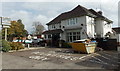
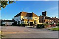
The Easington, Banbury
Ember Inns pub at 135 Bloxham Road, on the corner of Springfield Avenue.
Image: © Jaggery
Taken: 18 Oct 2014
0.06 miles
6
Semi-detached houses on Springfield Avenue
There is an OS benchmark Image on the side of the near house at its front corner
Image: © Roger Templeman
Taken: 29 Apr 2014
0.06 miles
7
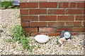
Benchmark on #35 Springfield Avenue
Ordnance Survey cut mark benchmark described on the Bench Mark Database at http://www.bench-marks.org.uk/bm57133
Image: © Roger Templeman
Taken: 29 Apr 2014
0.06 miles
8
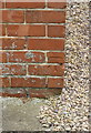
Benchmark on #1 Springfield Avenue
Ordnance Survey cut mark benchmark described on the Bench Mark Database at http://www.bench-marks.org.uk/bm57355
Image: © Roger Templeman
Taken: 16 May 2014
0.06 miles
9
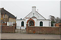
St Hugh's Church, Banbury
In Ruskin Road, Easington.
Image: © David Stowell
Taken: 10 Sep 2006
0.08 miles
10
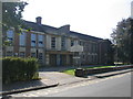
Banbury School
Some of the older school buildings in Ruskin Road.
Image: © David Stowell
Taken: 10 Sep 2006
0.08 miles