IMAGES TAKEN NEAR TO
White Post Road, BANBURY, OX16 6SZ
Introduction
This page details the photographs taken nearby to White Post Road, OX16 6SZ by members of the Geograph project.
The Geograph project started in 2005 with the aim of publishing, organising and preserving representative images for every square kilometre of Great Britain, Ireland and the Isle of Man.

There are currently over 7.5m images from over14,400 individuals and you can help contribute to the project by visiting https://www.geograph.org.uk
Image Map (Loading...)


Getting Data...Please wait
Leaflet Map data © OpenStreetMap
Images are licensed for reuse under creativecommons.org/licenses/by-sa/2.0
Notes
- Clicking on the map will re-center to the selected point.
- The higher the marker number, the further away the image location is from the centre of the postcode.
Image Listing (36 Images Found)
Images are licensed for reuse under creativecommons.org/licenses/by-sa/2.0
Image
Details
Distance
3
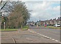
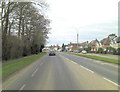
Junction of Broad Gap and High Street
One very common street name and one quite unusual one.
Image: © Des Blenkinsopp
Taken: 17 Dec 2018
0.09 miles
4
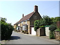
Horse and Jockey, Bodicote
One of few pubs still sporting a Courage sign (just!) although has not served a genuine pint of Courage Directors for many a year.
Image: © al partington
Taken: 11 May 2006
0.14 miles
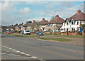
5
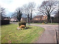
Broad Gap Bodicote
At the junction with the Banbury to Oxford road. There is always a sense of civic pride at this junction with tended flower beds and mowed grass.
Image: © Dennis Turner
Taken: 9 Apr 2006
0.16 miles
9
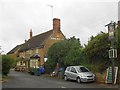
Bodicote: The Horse and Jockey
The Horse and Jockey is down Malthouse Lane. The Courage sign mentioned in the description for Image has now completely gone, along with the rest of the then existing pub sign name on the flank wall.
Incidentally the 1882 large scale Ordnance Survey map of the village calls it Boddicot throughout.
Image: © Nigel Cox
Taken: 27 Jul 2015
0.18 miles