IMAGES TAKEN NEAR TO
Haslemere Way, BANBURY, OX16 5TY
Introduction
This page details the photographs taken nearby to Haslemere Way, OX16 5TY by members of the Geograph project.
The Geograph project started in 2005 with the aim of publishing, organising and preserving representative images for every square kilometre of Great Britain, Ireland and the Isle of Man.

There are currently over 7.5m images from over14,400 individuals and you can help contribute to the project by visiting https://www.geograph.org.uk
Image Map
Images are licensed for reuse under creativecommons.org/licenses/by-sa/2.0
Notes
- Clicking on the map will re-center to the selected point.
- The higher the marker number, the further away the image location is from the centre of the postcode.
Image Listing (417 Images Found)
Images are licensed for reuse under creativecommons.org/licenses/by-sa/2.0
Image
Details
Distance
1
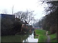
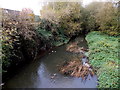
Oxford Canal: Site of former Swing Bridge Number 167
The narrow constriction in the distance is the site of former Swing Bridge Number 167. From old large scale Ordnance Survey maps its function appeared to be to provide access from the developed part of Banbury to the canal towpath and the meadows on the west bank of the River Cherwell.
Image: © Nigel Cox
Taken: 9 Jun 2019
0.01 miles
2
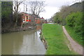
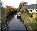
Canal drawbridge and towpath
There is an Ordnance Survey rivet benchmark on the wall of the drawbridge foundations on the left hand side bank of the canal (the drawbridge itself has gone). Information on the benchmark is available on the Bench Mark Database at http://www.bench-marks.org.uk/bm30511
Image: © Roger Templeman
Taken: 24 Apr 2013
0.02 miles
3
Former lift bridge foundations
On the Oxford Canal in Banbury.
Image: © Andrew Abbott
Taken: 7 Sep 2020
0.03 miles
4
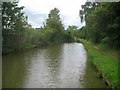
Upstream along the Cherwell, Banbury
Viewed from Tramway Road bridge. The River Cherwell is a major tributary of the River Thames, into which it flows at Oxford.
Image: © Jaggery
Taken: 18 Oct 2014
0.04 miles
5
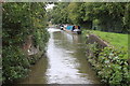
Canalside vessel, Banbury
Moored at the edge of the Oxford Canal. Carrs House is on the right.
Image: © Jaggery
Taken: 18 Oct 2014
0.04 miles
7

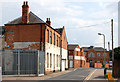
Magnet Kitchens showroom on Tramway Road, Banbury
Image: © Ian S
Taken: 26 Aug 2019
0.04 miles
8
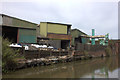
Industry alongside the Oxford canal at Banbury
Image: © Robert Eva
Taken: 23 Jun 2018
0.05 miles
9

Swan Foundry
Industrial site on the Oxford Canal in Banbury.
Image: © Andrew Abbott
Taken: 7 Sep 2020
0.05 miles