IMAGES TAKEN NEAR TO
Church Passage, BANBURY, OX16 5JZ
Introduction
This page details the photographs taken nearby to Church Passage, OX16 5JZ by members of the Geograph project.
The Geograph project started in 2005 with the aim of publishing, organising and preserving representative images for every square kilometre of Great Britain, Ireland and the Isle of Man.

There are currently over 7.5m images from over14,400 individuals and you can help contribute to the project by visiting https://www.geograph.org.uk
Image Map
Images are licensed for reuse under creativecommons.org/licenses/by-sa/2.0
Notes
- Clicking on the map will re-center to the selected point.
- The higher the marker number, the further away the image location is from the centre of the postcode.
Image Listing (897 Images Found)
Images are licensed for reuse under creativecommons.org/licenses/by-sa/2.0
Image
Details
Distance
1
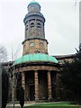
St Mary's Church, Banbury
Grade 1 listed late Georgian building erected in the last decade of the 18th century and consecrated in September 1797, presently used by the Anglican and United Reformed Churches http://www.stmaryschurch-banbury.org.uk/home/
Image: © Paul Gillett
Taken: 9 Mar 2013
0.02 miles
2
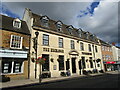
The Exchange, Banbury
The former Post Office. Designed by the Office of Works 1935-6.
Image: © Jonathan Thacker
Taken: 27 Sep 2021
0.03 miles
3
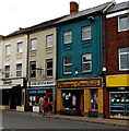
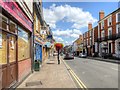
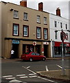
Peepers Opticians in Banbury
Viewed across High Street. Peepers Opticians is on the right, Cori Italian cuisine restaurant on the left.
Image: © Jaggery
Taken: 18 Oct 2014
0.03 miles
4
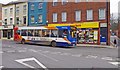
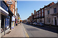
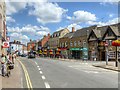
Stagecoach bus on route 488 in High Street, Banbury
A Stagecoach bus passes a pawnbrokers in High Street. It is on route 488 which runs between Banbury and Chipping Norton via the village of Bloxham.
Image: © P L Chadwick
Taken: 9 Mar 2013
0.03 miles
5
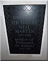
St Mary, Banbury: memorial (c)
For more details see http://en.wikipedia.org/wiki/Neil_Marten
Image: © Basher Eyre
Taken: 9 Mar 2013
0.03 miles
8
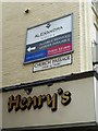
Signs in central Banbury
Tink-a-Tank refers to the Sanctus Bell http://en.wikipedia.org/wiki/Sanctus_bell_(church_bell)#Types
(Victoria County History Volume 11: Wootton Hundred (northern part) 1983 edited by Alan Crossley)
Image: © Basher Eyre
Taken: 9 Mar 2013
0.03 miles
10
Banbury Post Office
At 57-58 High Street, between Office Angels recruitment consultants on the left and KFC on the right.
Image: © Jaggery
Taken: 18 Oct 2014
0.03 miles