IMAGES TAKEN NEAR TO
Water Works Road, BANBURY, OX16 3JJ
Introduction
This page details the photographs taken nearby to Water Works Road, OX16 3JJ by members of the Geograph project.
The Geograph project started in 2005 with the aim of publishing, organising and preserving representative images for every square kilometre of Great Britain, Ireland and the Isle of Man.

There are currently over 7.5m images from over14,400 individuals and you can help contribute to the project by visiting https://www.geograph.org.uk
Image Map
Images are licensed for reuse under creativecommons.org/licenses/by-sa/2.0
Notes
- Clicking on the map will re-center to the selected point.
- The higher the marker number, the further away the image location is from the centre of the postcode.
Image Listing (53 Images Found)
Images are licensed for reuse under creativecommons.org/licenses/by-sa/2.0
Image
Details
Distance
1
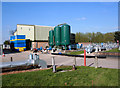
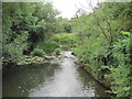
Grimsbury Water Treatment Works
Part of Thames Water's treatment site.
The stainless steel cylinder in the foreground is a tipping bucket rain gauge providing real time rainfall intensity data via telemetry.
It is operated by the Environment Agency, and the data is also used by the Met. Office.
The copper cylinder next to it is a check gauge which is read manually every month just to check that the automatic readings tally.
I have no idea what the big green tanks do,
Image: © Des Blenkinsopp
Taken: 27 Apr 2010
0.06 miles
2
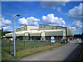
Grimsbury Water Treatment Works 2
Another view of this Thames Water site.
Image: © Des Blenkinsopp
Taken: 10 May 2010
0.10 miles

4
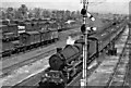
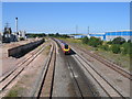
Birkenhead - Margate/Eastbourne express approaching Banbury
View northward at Banbury Junction Yards, towards Birmingham etc. on the GWR main line (left), also (right) the ex-GC line to Woodford Halse, Leicester and the North; these were major yards for the exchange of freight traffic between the two north-south systems. Collett-design 4-6-0 No. 7008 'Swansea Castle' (built 5/48, withdrawn 9/64) has taken on the 07.40 ex-Birkenhead Woodside at Wolverhampton and is working to Reading, whence successive SR locomotives will work the several parts of the multiple train via Redhill, then Brighton/Eastbourne and Tonbridge/Ashford/Folkestone/Margate. (The train seems to be made up mainly of SR stock).
Image: © Ben Brooksbank
Taken: 13 May 1950
0.13 miles
7
Site of Banbury yards
A modern DMU heads towards Leamington and Birmingham along the ex-GWR main line. The modern sheds on the right now occupy the site of the once extensive Banbury sidings. Just beyond the further of them was the site of Banbury junction where the ex-Great Central Branch to Culworth Junction diverged to the right.
Image: © David Stowell
Taken: 15 Jul 2006
0.14 miles
8
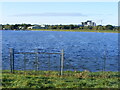
Grimsbury Reservoir, Banbury from the north
Grimsbury Reservoir with Mondelez (Kraft) factory in the distance.
Image: © Nick Barber
Taken: 9 Oct 2020
0.14 miles
10
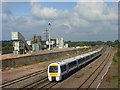
The railway, Banbury
This is the view north from an old road bridge just to the north of the modern A422 bridge. To the left of the tracks is a Lafarge cement or concrete works. The train is a southbound Chiltern Railways service.
Image: © Andrew Smith
Taken: 28 Sep 2008
0.15 miles