IMAGES TAKEN NEAR TO
Southam Road, BANBURY, OX16 2SE
Introduction
This page details the photographs taken nearby to Southam Road, OX16 2SE by members of the Geograph project.
The Geograph project started in 2005 with the aim of publishing, organising and preserving representative images for every square kilometre of Great Britain, Ireland and the Isle of Man.

There are currently over 7.5m images from over14,400 individuals and you can help contribute to the project by visiting https://www.geograph.org.uk
Image Map
Images are licensed for reuse under creativecommons.org/licenses/by-sa/2.0
Notes
- Clicking on the map will re-center to the selected point.
- The higher the marker number, the further away the image location is from the centre of the postcode.
Image Listing (69 Images Found)
Images are licensed for reuse under creativecommons.org/licenses/by-sa/2.0
Image
Details
Distance
5
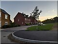
Cherry Fields estate, Banbury
On Bourton Road
Image: © David Howard
Taken: 17 Oct 2021
0.07 miles
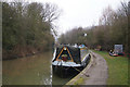
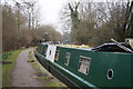
6
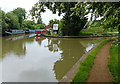
Grimsbury Wharf along the Oxford Canal
Image: © Mat Fascione
Taken: 23 May 2015
0.08 miles
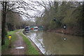
8
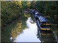
Oxford Canal in Banbury, looking north
The Oxford Canal is among the earliest of cuts in the canal age. It was initially designed by James Brindley, succeeded by Samuel Simcock and Robert Whitworth after Brindley's untimely death in 1772 at the age of 56. It was opened in sections between 1774 and 1790 with the purpose of bringing coal from the Coventry coalfields to Oxford and the River Thames. The canal formed part of Brindley's grand plan for a waterway 'cross' linking the rivers Thames, Mersey, Trent and Severn.(canalrivertrust.org.uk)
Image: © Nick Barber
Taken: 9 Oct 2020
0.08 miles
9
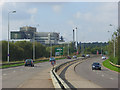
The A422, Banbury
The Kraft Foods factory dominates the scene on this eastern approach to the town from the M40. It is one of the world's largest facilities for the production of soluble coffee. It produces brands such as Kenco and Maxwell House and employs 1,100 people (Source: http://www.kraftfoods.co.uk/kraft/page?PagecRef=2297 ). The resultant aroma will be familiar to regular users of the nearby motorway.
Image: © Andrew Smith
Taken: 28 Sep 2008
0.08 miles
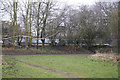
10
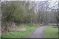
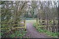
Path in Spiceball Country Park
Near the northern end of the park, close to the Oxford Canal.
Image: © Fernweh
Taken: 9 Mar 2013
0.08 miles