IMAGES TAKEN NEAR TO
Rye Close, BANBURY, OX16 1XG
Introduction
This page details the photographs taken nearby to Rye Close, OX16 1XG by members of the Geograph project.
The Geograph project started in 2005 with the aim of publishing, organising and preserving representative images for every square kilometre of Great Britain, Ireland and the Isle of Man.

There are currently over 7.5m images from over14,400 individuals and you can help contribute to the project by visiting https://www.geograph.org.uk
Image Map (Loading...)


Getting Data...Please wait
Leaflet Map data © OpenStreetMap
Images are licensed for reuse under creativecommons.org/licenses/by-sa/2.0
Notes
- Clicking on the map will re-center to the selected point.
- The higher the marker number, the further away the image location is from the centre of the postcode.
Image Listing (12 Images Found)
Images are licensed for reuse under creativecommons.org/licenses/by-sa/2.0
Image
Details
Distance
1
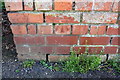
Benchmark on wall of Highlands
Ordnance Survey cut mark benchmark described on the Bench Mark Database at http://www.bench-marks.org.uk/bm75698
Image: © Roger Templeman
Taken: 20 Apr 2016
0.06 miles
2
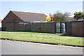
Electricity substation, Highlands
There is an OS benchmark Image on the wall jut to the right of the substation gates.
Image: © Roger Templeman
Taken: 20 Apr 2016
0.06 miles
3
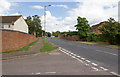
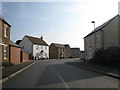
Highlands, Banbury
Looking ENE up Highlands past the junction with Hardwick Park.
Image: © David P Howard
Taken: 3 Aug 2013
0.09 miles
4
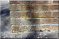
Benchmark on #12 Jersey Drive
Ordnance Survey cut mark benchmark described on the Bench Mark Database at http://www.bench-marks.org.uk/bm75697
Image: © Roger Templeman
Taken: 20 Apr 2016
0.09 miles
5
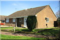
#12 Jersey Drive
There is an OS benchmark Image on the near angle, right hand face, of the bungalow
Image: © Roger Templeman
Taken: 20 Apr 2016
0.09 miles
6
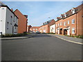
Winter Gardens Way, Banbury
Part of the large Hanwell Fields development, at the junction with Sage Close (Many roads in the development are named after herbs). Interestingly for such a large housing development the mixture of different house designs is such that it is almost impossible to see any two that are identical in the same view.
Image: © David Stowell
Taken: 20 Mar 2009
0.16 miles
7
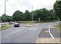
Roundabout on B4100 Warwick Road, Banbury
Serving a residential area off to the left.
Image: © Robin Webster
Taken: 30 May 2021
0.17 miles
8
Usher Drive, Banbury
At the entrance to the large Hanwell Fields development. Interestingly for such a large housing development the mixture of different house designs is such that it is almost impossible to see any two that are identical in the same view.
Image: © David Stowell
Taken: 20 Mar 2009
0.17 miles
9
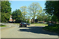
Roundabout at the end of Highlands
The roundabout on the B4100 Warwick Road junction with Highlands.
Image: © David P Howard
Taken: 3 Aug 2013
0.17 miles
10
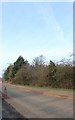
Warwick Road, Drayton
A little resurfacing is going on here.
Image: © David Howard
Taken: 9 Feb 2019
0.18 miles