IMAGES TAKEN NEAR TO
Otters Reach, OXFORD, OX1 5QL
Introduction
This page details the photographs taken nearby to Otters Reach, OX1 5QL by members of the Geograph project.
The Geograph project started in 2005 with the aim of publishing, organising and preserving representative images for every square kilometre of Great Britain, Ireland and the Isle of Man.

There are currently over 7.5m images from over14,400 individuals and you can help contribute to the project by visiting https://www.geograph.org.uk
Image Map
Images are licensed for reuse under creativecommons.org/licenses/by-sa/2.0
Notes
- Clicking on the map will re-center to the selected point.
- The higher the marker number, the further away the image location is from the centre of the postcode.
Image Listing (122 Images Found)
Images are licensed for reuse under creativecommons.org/licenses/by-sa/2.0
Image
Details
Distance


10
National Grid
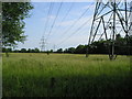
Power lines over the water meadows owned by the Oxford Preservation Trust. Pylons are a necessary and accepted part of the scenery, but if it were suggested that wind turbines might be erected here, there would be an outcry!
Image: © Marion Phillips
Taken: 30 Jun 2009
0.10 miles