IMAGES TAKEN NEAR TO
Ushercombe View, BANBURY, OX15 5TF
Introduction
This page details the photographs taken nearby to Ushercombe View, OX15 5TF by members of the Geograph project.
The Geograph project started in 2005 with the aim of publishing, organising and preserving representative images for every square kilometre of Great Britain, Ireland and the Isle of Man.

There are currently over 7.5m images from over14,400 individuals and you can help contribute to the project by visiting https://www.geograph.org.uk
Image Map
Images are licensed for reuse under creativecommons.org/licenses/by-sa/2.0
Notes
- Clicking on the map will re-center to the selected point.
- The higher the marker number, the further away the image location is from the centre of the postcode.
Image Listing (33 Images Found)
Images are licensed for reuse under creativecommons.org/licenses/by-sa/2.0
Image
Details
Distance
1

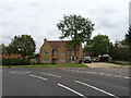
Swalcliffe Road, Tadmarton
Swalcliffe Road, the B4035 just to the west of Tadmarton.
Image: © Philip Halling
Taken: 12 Jul 2012
0.02 miles
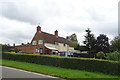
3
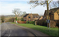
B4035 west of Tadmarton
The B4035 approaches Tadmarton from the west via a double bend past a small development of modern houses.
Image: © Stephen McKay
Taken: 4 Feb 2007
0.05 miles
4
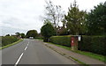
Swalcliffe Road, Tadmarton
Showing position of Postbox No. OX15 1095.
See Image] for postbox.
Image: © JThomas
Taken: 5 Oct 2019
0.06 miles
5
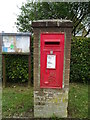
Elizabeth II postbox on Swalcliffe Road, Tadmarton
Postbox No. OX15 1095.
See Image] for context.
Image: © JThomas
Taken: 5 Oct 2019
0.07 miles
6
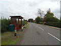
Bus stop and shelter on Swalcliffe Road, Tadmarton
Image: © JThomas
Taken: 5 Oct 2019
0.08 miles
8
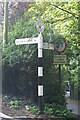
Direction Sign ? Signpost on the B4035 in Tadmarton
Located on the northwest side of the junction of the B4035 Main Street and Green Lane in Tadmarton parish. 2 arms and annulus finial.
Milestone Society National ID: OX_SP3937
Image: © John V Nicholls
Taken: 14 Sep 2007
0.17 miles
10
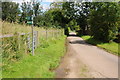
Country road at Tadmarton
The footpath on the left leads to Upper Lea Farm.
Image: © Philip Halling
Taken: 12 Jul 2012
0.18 miles