IMAGES TAKEN NEAR TO
Lower Tadmarton, BANBURY, OX15 5SY
Introduction
This page details the photographs taken nearby to OX15 5SY by members of the Geograph project.
The Geograph project started in 2005 with the aim of publishing, organising and preserving representative images for every square kilometre of Great Britain, Ireland and the Isle of Man.

There are currently over 7.5m images from over14,400 individuals and you can help contribute to the project by visiting https://www.geograph.org.uk
Image Map (Loading...)


Getting Data...Please wait
Leaflet Map data © OpenStreetMap
Images are licensed for reuse under creativecommons.org/licenses/by-sa/2.0
Notes
- Clicking on the map will re-center to the selected point.
- The higher the marker number, the further away the image location is from the centre of the postcode.
Image Listing (15 Images Found)
Images are licensed for reuse under creativecommons.org/licenses/by-sa/2.0
Image
Details
Distance
1
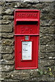
Elizabeth II postbox on the B4035, Lower Tadmarton
Postbox No. OX15 1005.
See Image] for context.
Image: © JThomas
Taken: 5 Oct 2019
0.01 miles
2
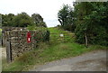
Field entrance off the B4035, Lower Tadmarton
Showing position of Postbox No. OX15 1005.
See Image] for postbox.
Image: © JThomas
Taken: 5 Oct 2019
0.01 miles
3
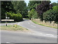
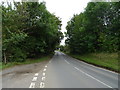
Road to Shutford
This junction off the B4035 crosses over a small brook before the bend to the left on its way to Shutford. The road sign has to be circa 1950s?
Image: © Michael Patterson
Taken: 12 Jul 2006
0.01 miles
5
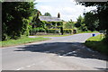
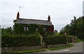
Road junction, Lower Tadmarton
Cottage on a road junction at Lower Tadmarton.
Image: © Philip Halling
Taken: 12 Jul 2012
0.01 miles
6
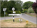
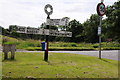
Lower Tadmarton, fingerpost
Well-maintained traditional Oxfordshire fingerpost, with county name in a roundel, and metal arms.
Image: © Mike Faherty
Taken: 2 Jul 2010
0.01 miles
8
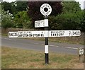
Old Direction Sign - Signpost by the B4035, Lower Tadmarton
Annulus finial - 3 arms; Oxford CC halo by the B4035, in parish of Tadmarton (Cherwell District), Lower Tadmarton - Junction of B4035 and Shutford Road, in centre of grassy island.
Surveyed
Milestone Society National ID: OX_SP4037.
Image: © Milestone Society
Taken: Unknown
0.02 miles

10
Traditional roadsign
A traditional Oxford County roadsign at Lower Tadmarton.
Image: © Philip Halling
Taken: 12 Jul 2012
0.02 miles