IMAGES TAKEN NEAR TO
The Sidings, BANBURY, OX15 5QF
Introduction
This page details the photographs taken nearby to The Sidings, OX15 5QF by members of the Geograph project.
The Geograph project started in 2005 with the aim of publishing, organising and preserving representative images for every square kilometre of Great Britain, Ireland and the Isle of Man.

There are currently over 7.5m images from over14,400 individuals and you can help contribute to the project by visiting https://www.geograph.org.uk
Image Map (Loading...)


Getting Data...Please wait
Leaflet Map data © OpenStreetMap
Images are licensed for reuse under creativecommons.org/licenses/by-sa/2.0
Notes
- Clicking on the map will re-center to the selected point.
- The higher the marker number, the further away the image location is from the centre of the postcode.
Image Listing (34 Images Found)
Images are licensed for reuse under creativecommons.org/licenses/by-sa/2.0
Image
Details
Distance
1
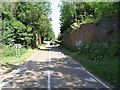
East End Railway
This former bridge once carried the railway from Hook Norton towards the east. The former station was just to the right.
Image: © Michael Patterson
Taken: 12 Jul 2006
0.02 miles
2
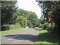
The road leaving Hook Norton
The Banbury to Cheltenham railway line once crossed this road on a bridge just beyond the delimit sign. The overgrown abutments can just be seen.
Image: © Sarah Charlesworth
Taken: 25 Aug 2009
0.03 miles
3
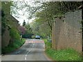
Entering Hook Norton
The former railway bridge carried the railway line from Banbury to Kingham.
Image: © David Luther Thomas
Taken: 20 Apr 2007
0.03 miles
4
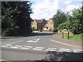
Modern houses in Ironstone Hollow, Hook Norton
The road name refers to the extensive ironstone extraction that took place to the east of Hook Norton.
Image: © Sarah Charlesworth
Taken: 25 Aug 2009
0.14 miles
5
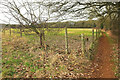
Footpath to Hook Norton
As with Image], footpath 253 22/20 passes a field boundary on the diagonal.
Image: © Derek Harper
Taken: 9 Feb 2022
0.14 miles
6
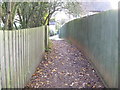
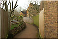
Between the houses
The footpath passes along the well surfaced alley between the houses in Hook Norton.
Image: © Michael Dibb
Taken: 12 Nov 2011
0.15 miles
7
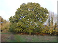
Fine tree
This lovely old oak tree is alongside the footpath.
Image: © Michael Dibb
Taken: 12 Nov 2011
0.15 miles
8
D'Arcy Dalton Way [4]
The footpath crosses the road named Ironstone Hollow.
Image: © Michael Dibb
Taken: 12 Nov 2011
0.15 miles
9
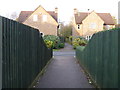
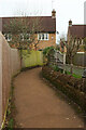
D'Arcy Dalton Way, Ironstone Hollow
A reverse view of Image
Image: © Derek Harper
Taken: 10 Feb 2022
0.15 miles
10
D'Arcy Dalton Way, Ironstone Hollow
Following footpath 253 19/10 between bits of the cul-de-sac.
Image: © Derek Harper
Taken: 10 Feb 2022
0.16 miles