IMAGES TAKEN NEAR TO
East End, BANBURY, OX15 5LG
Introduction
This page details the photographs taken nearby to East End, OX15 5LG by members of the Geograph project.
The Geograph project started in 2005 with the aim of publishing, organising and preserving representative images for every square kilometre of Great Britain, Ireland and the Isle of Man.

There are currently over 7.5m images from over14,400 individuals and you can help contribute to the project by visiting https://www.geograph.org.uk
Image Map (Loading...)


Getting Data...Please wait
Leaflet Map data © OpenStreetMap
Images are licensed for reuse under creativecommons.org/licenses/by-sa/2.0
Notes
- Clicking on the map will re-center to the selected point.
- The higher the marker number, the further away the image location is from the centre of the postcode.
Image Listing (48 Images Found)
Images are licensed for reuse under creativecommons.org/licenses/by-sa/2.0
Image
Details
Distance
1

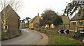
Station Road, Hook Norton
This view from the autumn of 1997 shows a thatched cottage and other houses built in the attractive local stone. Hook Norton is a relatively large village for north Oxfordshire best known for its brewery. Sadly the station from which this road takes its name closed to passengers in 1951.
Image: © Stephen McKay
Taken: 1 Oct 1997
0.02 miles
2
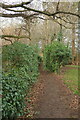
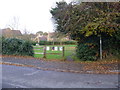
East End, Hook Norton
Bending on the way towards the village centre. This is from the D'Arcy Dalton Way as it converges on the road.
Image: © Derek Harper
Taken: 10 Feb 2022
0.03 miles
3
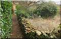
D'Arcy Dalton Way, Hook Norton
Another stretch of footpath 253 35/10 a little further east from Image
Image: © Derek Harper
Taken: 10 Feb 2022
0.04 miles
4
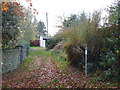
D'Arcy Dalton Way, Hook Norton
Following the narrow footpath 253 35/10 between Hollybush Road and the eat end of the village.
Image: © Derek Harper
Taken: 10 Feb 2022
0.05 miles

6
D'Arcy Dalton Way [6]
The footpath continues through Hook Norton.
Image: © Michael Dibb
Taken: 12 Nov 2011
0.05 miles
7
D'Arcy Dalton Way [5]
The footpath continues through Hook Norton, here crossing a small green.
Image: © Michael Dibb
Taken: 12 Nov 2011
0.07 miles
8
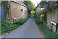
Tite Lane
It does look to be a bit of a squeeze
Image: © Philip Jeffrey
Taken: 27 Sep 2020
0.07 miles
9
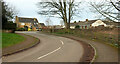
Hollybush Road, Hook Norton
From where the D'Arcy Dalton Way crosses it.
Image: © Derek Harper
Taken: 10 Feb 2022
0.08 miles
10
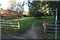
D'Arcy Dalton Way wanders across the green
Image: © Philip Jeffrey
Taken: 27 Sep 2020
0.09 miles