IMAGES TAKEN NEAR TO
Winderton, BANBURY, OX15 5JG
Introduction
This page details the photographs taken nearby to OX15 5JG by members of the Geograph project.
The Geograph project started in 2005 with the aim of publishing, organising and preserving representative images for every square kilometre of Great Britain, Ireland and the Isle of Man.

There are currently over 7.5m images from over14,400 individuals and you can help contribute to the project by visiting https://www.geograph.org.uk
Image Map (Loading...)


Getting Data...Please wait
Leaflet Map data © OpenStreetMap
Images are licensed for reuse under creativecommons.org/licenses/by-sa/2.0
Notes
- Clicking on the map will re-center to the selected point.
- The higher the marker number, the further away the image location is from the centre of the postcode.
Image Listing (30 Images Found)
Images are licensed for reuse under creativecommons.org/licenses/by-sa/2.0
Image
Details
Distance
2
Stone buildings, Winderton
They and many other buildings locally are built of Marlstone Rock, also known as Hornton Stone after the quarries around Hornton and Edgehill. It is an iron-rich shelly limestone that is blue-green freshly quarried, oxidising to brown.
Image: © Robin Stott
Taken: 18 Oct 2012
0.02 miles
3
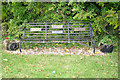
Royal seat, Winderton
This seat with a view across the valley has had a plaque added since Michael Dibb's Image of 2011:
Queen Elizabeth II
Diamond Jubilee
2012
Image: © Robin Stott
Taken: 18 Oct 2012
0.03 miles
4
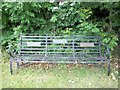
Jubilee bench
The tree plates on this metal bench commemorate (1) the diamond jubilee of Queen Victoria in 1897 (2) the silver jubilee of Queen Elizabeth in 1977 and (3) the golden jubilee of Queen Elizabeth in 2002. Presumably a plate will be added in 2012 for the diamond jubilee of Queen Elizabeth.
Image: © Michael Dibb
Taken: 11 Jun 2011
0.03 miles
5
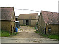
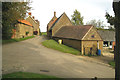
Barns at farmyard entrance, Underhill Farm, Winderton
The rooflines of the nearer barns follow the slope of the ground. They and many other buildings locally are built of Marlstone Rock, also known as Hornton Stone after the quarries around Hornton and Edgehill. It is an iron-rich shelly limestone that is blue-green freshly quarried, oxidising to brown.
Image: © Robin Stott
Taken: 18 Oct 2012
0.03 miles
6
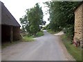
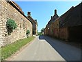
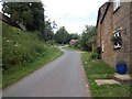
Village junction
Behind the camera to Compton Wynyates and Epwell; straight on to Upper Brailes; left to Lower Brailes.
Image: © Michael Dibb
Taken: 11 Jun 2011
0.04 miles
7
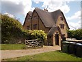
Hay House
Originally two 17th century cottages, this attractive house is listed grade II. More details at: http://www.britishlistedbuildings.co.uk/en-305825-hay-house-brailes
Image: © Michael Dibb
Taken: 11 Jun 2011
0.04 miles
8
Winderton Warwickshire
A very sleepy village with a rather grand church
Image: © John Smith
Taken: 12 Nov 2005
0.06 miles
9
Winderton Village
Looking up towards the road junction.
Image: © Michael Dibb
Taken: 11 Jun 2011
0.06 miles
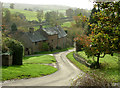
10
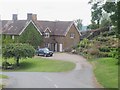
Underhill Farm
The farmhouse has an attractive garden.
Image: © Michael Dibb
Taken: 11 Jun 2011
0.07 miles