IMAGES TAKEN NEAR TO
Lower Brailes, BANBURY, OX15 5JD
Introduction
This page details the photographs taken nearby to OX15 5JD by members of the Geograph project.
The Geograph project started in 2005 with the aim of publishing, organising and preserving representative images for every square kilometre of Great Britain, Ireland and the Isle of Man.

There are currently over 7.5m images from over14,400 individuals and you can help contribute to the project by visiting https://www.geograph.org.uk
Image Map (Loading...)


Getting Data...Please wait
Leaflet Map data © OpenStreetMap
Images are licensed for reuse under creativecommons.org/licenses/by-sa/2.0
Notes
- Clicking on the map will re-center to the selected point.
- The higher the marker number, the further away the image location is from the centre of the postcode.
Image Listing (105 Images Found)
Images are licensed for reuse under creativecommons.org/licenses/by-sa/2.0
Image
Details
Distance
1
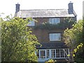
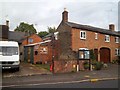
Brailes cottage
This attractive property is in Salt Way Lane, Lower Brailes.
Image: © Michael Dibb
Taken: 11 Jun 2011
0.05 miles
2
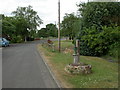
Lower Brailes, village pump
Recently re-instated, in Rectory Lane; possibly originally replacing the structure to the right, which might have been the village well.
Image: © Mike Faherty
Taken: 2 Jul 2010
0.07 miles
3
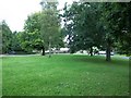
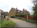
Village green
This small green is alongside the B4035 road in Lower Brailes.
Image: © Michael Dibb
Taken: 29 Aug 2010
0.07 miles
4
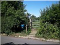
Footpath leaves road
The village and surrounding area of Lower Brailes is criss-crossed with many footpaths well looked after by the local footpath society. Here a footpath to the church leaves Salt Way Lane.
Image: © Michael Dibb
Taken: 11 Jun 2011
0.09 miles
5
The Forge, Lower Brailes
Still occupied by a working blacksmith.
Image: © Michael Dibb
Taken: 29 Aug 2010
0.11 miles
7
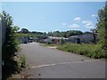
Industrial estate
On the edge of the village of Lower Brailes is this small industrial estate. Seen from Salt Way Lane.
Image: © Michael Dibb
Taken: 11 Jun 2011
0.12 miles
8
Church and spinney
From Salt Way Lane is this view of the tower of the church of St George. On the skyline to the left of the image is Highwall Spinney atop Brailes Hill.
Image: © Michael Dibb
Taken: 11 Jun 2011
0.13 miles
9
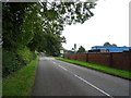
B4035 near Green End Farm
Towards Swalcliffe.
Image: © JThomas
Taken: 5 Oct 2019
0.13 miles
10
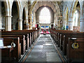
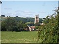
Lower Brailes: St George's church
Brailes (Upper and Lower) is an attractive village surrounded by hills at the southern extremity of Warwickshire, bordering Oxfordshire to the east. Located 4 miles east of Shipston-on-Stour on the B4035 Shipston to Banbury road, the village lies within the Cotswold Area of Outstanding Natural Beauty. The magnificent 120 foot Perpendicular tower of the Grade I Listed St.George's Church, with its four pinnacles, is an easily distinguished landmark.
Image: © Francois Thomas
Taken: 14 Apr 2008
0.13 miles