IMAGES TAKEN NEAR TO
East Street, BANBURY, OX15 4DJ
Introduction
This page details the photographs taken nearby to East Street, OX15 4DJ by members of the Geograph project.
The Geograph project started in 2005 with the aim of publishing, organising and preserving representative images for every square kilometre of Great Britain, Ireland and the Isle of Man.

There are currently over 7.5m images from over14,400 individuals and you can help contribute to the project by visiting https://www.geograph.org.uk
Image Map (Loading...)


Getting Data...Please wait
Leaflet Map data © OpenStreetMap
Images are licensed for reuse under creativecommons.org/licenses/by-sa/2.0
Notes
- Clicking on the map will re-center to the selected point.
- The higher the marker number, the further away the image location is from the centre of the postcode.
Image Listing (67 Images Found)
Images are licensed for reuse under creativecommons.org/licenses/by-sa/2.0
Image
Details
Distance
1
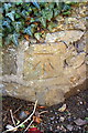
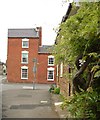
Benchmark on Draycott House, East Street
Ordnance Survey cut mark benchmark described on the Bench Mark Database at http://www.bench-marks.org.uk/bm52357
Image: © Roger Templeman
Taken: 29 Oct 2013
0.03 miles
2
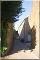
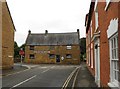
Chapel Lane from East Street
The house on the left is Draycott House (with an OS benchmark Image on the corner at the bottom left of the image) and the white door on the right is the entrance to Rhubarb Cottage
Image: © Roger Templeman
Taken: 29 Oct 2013
0.03 miles
3
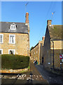
Chapel Lane, Bodicote
Very narrow at this end but widens out a short way along.
Image: © Des Blenkinsopp
Taken: 17 Dec 2018
0.04 miles
4
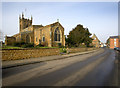
St John the Baptist Parish Church, Bodicote
Looking north up the High Street, the Pub is the Plough. The junction with East Street is to the right by the red brick house.
Image: © Ben Nicholson
Taken: 24 Jan 2006
0.05 miles
5
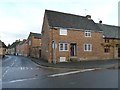
East Street
House on the corner of East Street and High Street, Bodicote.
Image: © Snidge
Taken: 22 May 2007
0.07 miles
6
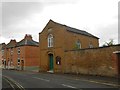
Bodicote: The Methodist Church
The church, which is on East Street, and which was built as the Wesleyan Chapel in 1845, is on the Banbury Circuit.
Image: © Nigel Cox
Taken: 27 Jul 2015
0.08 miles
7
Bodicote-East Street
The view from Church Street.The Methodist Chapel can be seen.
Image: © Ian Rob
Taken: 11 Dec 2015
0.09 miles
8
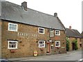
Bodicote: Former Baker's Arms now The Spice Room
This Grade II Listed Building occupies a prominent location at the junction of Church Street, East Street and the High Street. It was until recently the Baker's Arms, with a 2007 view here Image It is now a "Bar and Indian Restaurant". The National Heritage website describes it thus:-
"Public House. Datestone N/TE/1702. Steeply pitched Welsh slate roof. 3 brick stacks to ends and ridge. 3-unit plan. 2 storeys plus attic. 3-window range. C20 door to right flanked by two C20 sashes with wooden lintels. C20 window to left has original wooden lintel. Three C20 sashes to first floor, with original lintels. 2-light stone mullioned window to cellar to right. Stone copings."
Image: © Nigel Cox
Taken: 27 Jul 2015
0.10 miles
10
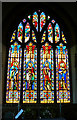
Stained glass window, the Parish Church of St John the Baptist, Bodicote
This is at the east end of the church above the altar. The four main windows are linked by the inscriptions at the bottom and commemorate the departure from this life of a gentleman named George Warriner, late of Bloxham Grove aged 62, in 1845. George was the father of the curate responsible for the restoration of the church. The figures appear to be Jesus Christ and at least three of his disciples. More about the church on their website http://www.bodicotechurch.org/
Image: © Brian Robert Marshall
Taken: 2 Jun 2010
0.11 miles