IMAGES TAKEN NEAR TO
Wytham Street, OXFORD, OX1 4TS
Introduction
This page details the photographs taken nearby to Wytham Street, OX1 4TS by members of the Geograph project.
The Geograph project started in 2005 with the aim of publishing, organising and preserving representative images for every square kilometre of Great Britain, Ireland and the Isle of Man.

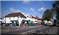
There are currently over 7.5m images from over14,400 individuals and you can help contribute to the project by visiting https://www.geograph.org.uk
Image Map
Images are licensed for reuse under creativecommons.org/licenses/by-sa/2.0
Notes
- Clicking on the map will re-center to the selected point.
- The higher the marker number, the further away the image location is from the centre of the postcode.
Image Listing (84 Images Found)
Images are licensed for reuse under creativecommons.org/licenses/by-sa/2.0
Image
Details
Distance
1
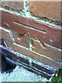
Benchmark on #75 Sunningwell Road (Wytham Street)
Ordnance Survey cut mark benchmark described in the Bench Mark Database at http://www.bench-marks.org.uk/bm35313.
Image: © Roger Templeman
Taken: 2 Sep 2010
0.06 miles
2
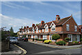
Sunningwell Road, New Hinksey
The western part of Sunningwell Road continues the terraced housing seen along the eastern section but in a later style.
Image
Image: © Des Blenkinsopp
Taken: 26 Jul 2023
0.07 miles
3
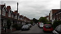
Sunningwell Road, New Hinksey
New Hinksey is mostly one block thick as it were, its side roads running between Abingdon Road and Wytham Street. Sunningwell Road is the only one to have a crossroads with Wytham Street, perceptible here in the gap between the terraces on the left hand side.
Image: © Chris Brown
Taken: 13 Jul 2017
0.07 miles
4
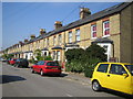
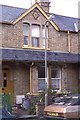
New Hinksey: Sunningwell Road
Victorian terraced houses typical of this area of south Oxford.
Image: © Nigel Cox
Taken: 23 Aug 2007
0.09 miles
5
Jewson Skoda
Skoda sales and service, corner of Abingdon Rd. and Northampton Rd.
Image: © Des Blenkinsopp
Taken: 14 Sep 2011
0.10 miles
6
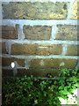
Benchmark and snail at #32 Sunningwell Road
Ordnance Survey cut mark benchmark described on the Bench Mark Database at http://www.bench-marks.org.uk/bm35314.
Image: © Roger Templeman
Taken: 2 Sep 2010
0.11 miles
7
Sunningwell Road, Oxford, 1987
A student shared house (taken the day before I moved out of it).
The back garden appears in Image and Image
Image: © Christopher Hilton
Taken: 29 Jun 1987
0.11 miles
8
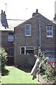
Back of terraced houses, Sunningwell Road, Oxford, 1987
The front of the house is seen in Image
Image: © Christopher Hilton
Taken: 30 Jun 1987
0.12 miles
9
South Oxford Baptist Church on Wytham Street
Image: © Steve Daniels
Taken: 21 Nov 2017
0.12 miles
10
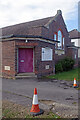
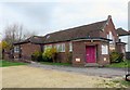
South Oxford Christian Centre
This church was built in 1938 which would make it roughly contemporary with the semi-detached houses that surround it on Wytham Street. It was originally the South Oxford Baptist Church but is now the South Oxford Christian Centre and home of the Oxford Corps of the Salvation Army.
Image: © Stephen McKay
Taken: 2 Nov 2021
0.12 miles