IMAGES TAKEN NEAR TO
Marlborough Road, OXFORD, OX1 4LU
Introduction
This page details the photographs taken nearby to Marlborough Road, OX1 4LU by members of the Geograph project.
The Geograph project started in 2005 with the aim of publishing, organising and preserving representative images for every square kilometre of Great Britain, Ireland and the Isle of Man.

There are currently over 7.5m images from over14,400 individuals and you can help contribute to the project by visiting https://www.geograph.org.uk
Image Map
Images are licensed for reuse under creativecommons.org/licenses/by-sa/2.0
Notes
- Clicking on the map will re-center to the selected point.
- The higher the marker number, the further away the image location is from the centre of the postcode.
Image Listing (119 Images Found)
Images are licensed for reuse under creativecommons.org/licenses/by-sa/2.0
Image
Details
Distance
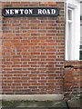
1
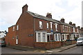
Junction of Newton Road and Marlborough Road
There is an OS benchmark Image in the bricks at the junction of the corner house and its front side wall, below the Newton Road sign
Image: © Roger Templeman
Taken: 22 Feb 2014
0.02 miles
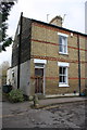
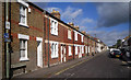
2
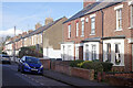
Marlborough Road, Grandpont
This street was developed in the early 1880s. Its name comes from the Duke of Marlborough who was a major landowner in the area. Newton Road leads off to the right.
Image: © Stephen McKay
Taken: 2 Nov 2021
0.02 miles
3
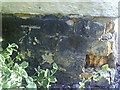
Benchmark on #270 Marlborough Road
Ordnance Survey cut mark benchmark described on the Bench Mark Database at http://www.bench-marks.org.uk/bm35384.
Image: © Roger Templeman
Taken: 2 Sep 2010
0.03 miles
6
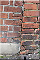
Benchmark on #135 Marlborough Road (Newton Road face)
Ordnance Survey cut mark benchmark described on the Bench Mark Database at http://www.bench-marks.org.uk/bm54651
Image: © Roger Templeman
Taken: 22 Feb 2014
0.03 miles
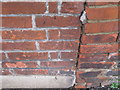
7
#270 Marlborough Road
There is an OS benchmark Image on the side of the house at the front corner, partly covered by a concrete block protecting damaged brickwork
Image: © Roger Templeman
Taken: 22 Feb 2014
0.03 miles
8

Eastwyke Ditch from the footbridge
Eastwyke Ditch flows between Hinksey Stream and the River Thames.
Image: © Steve Daniels
Taken: 22 Sep 2012
0.04 miles
9
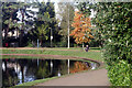
Hinksey Park
Looking across the boating lake where a woman seems to be contemplating life - or perhaps checking her phone.
Image: © Stephen McKay
Taken: 2 Nov 2021
0.06 miles
10
Marlborough Road, Grandpont
Grandpont is a community of terraced streets just south of the Thames from Oxford City centre.
Originally in Berkshire, this area was incorporated into Oxford at the end of the 19th century. You can see the Geograph "near to" caption still says South Hinksey, the Old Berkshire parish in which these streets were built, rather than Oxford which is much nearer.
It's unusual to get such a long view unobstructed by parking, but this is bike country. Nearly all the houses have cycle mooring rings let into the brickwork on the front wall.
Image: © Des Blenkinsopp
Taken: 14 Sep 2011
0.06 miles