IMAGES TAKEN NEAR TO
Shepherd Gardens, ABINGDON, OX14 5PR
Introduction
This page details the photographs taken nearby to Shepherd Gardens, OX14 5PR by members of the Geograph project.
The Geograph project started in 2005 with the aim of publishing, organising and preserving representative images for every square kilometre of Great Britain, Ireland and the Isle of Man.

There are currently over 7.5m images from over14,400 individuals and you can help contribute to the project by visiting https://www.geograph.org.uk
Image Map (Loading...)


Getting Data...Please wait
Leaflet Map data © OpenStreetMap
Images are licensed for reuse under creativecommons.org/licenses/by-sa/2.0
Notes
- Clicking on the map will re-center to the selected point.
- The higher the marker number, the further away the image location is from the centre of the postcode.
Image Listing (50 Images Found)
Images are licensed for reuse under creativecommons.org/licenses/by-sa/2.0
Image
Details
Distance
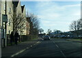
1
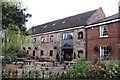
Estate across the meadow
The Wilts and Berks canal would have run where the hedge is but now a housing estate blocks the way.
Image: © Bill Nicholls
Taken: 5 Apr 2009
0.12 miles
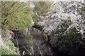
5
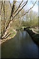
River past the weir
The River Ock as it flows away from the weir taken from the footbridge.
Image: © Bill Nicholls
Taken: 5 Apr 2009
0.18 miles
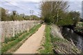
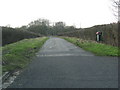
6
Mill Road heading towards New Cut Mill
In 1973 the Ordnance Survey verified a rivet benchmark, http://www.bench-marks.org.uk/bm22927 on a culvert for the ditch on the right hand side of the road at the junction of the hedge and fence. There is no sign of a culvert now. The fence is the boundary of the house at the west end of the housing along Mill Road
Image: © Roger Templeman
Taken: 16 Feb 2013
0.18 miles
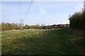
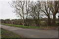
7
Track towards the river on the outskirts of Abingdon
Image: © Sarah Charlesworth
Taken: 19 Feb 2010
0.18 miles
9
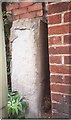
Old Bridge Marker by the B4017, Drayton Road, Abingdon
Bridge Marker by the B4017, in parish of Abingdon (Vale Of White Horse District), Drayton Road; opposite Ladygrove Court, before petrol station, against brick wall on the pavement, behind lamppost, West side of road.
Surveyed
Milestone Society National ID: BE_ABNE01br
Image: © Milestone Society
Taken: Unknown
0.18 miles